
Municipalities of Guerrero
.svg)
Municipalities in Guerrero are administratively autonomous of the state according to the 115th article of the 1917 Constitution.[4] Every three years, citizens elect a municipal president (Spanish: presidente municipal) by a plurality voting system who heads a concurrently elected municipal council (ayuntamiento) responsible for providing all the public services for their constituents. The municipal council consists of a variable number of trustees and councillors (regidores y síndicos).[5] Municipalities are responsible for public services (such as water and sewerage), street lighting, public safety, traffic, and the maintenance of public parks, gardens and cemeteries.[6] They may also assist the state and federal governments in education, emergency fire and medical services, environmental protection and maintenance of monuments and historical landmarks. Since 1984, they have had the power to collect property taxes and user fees, although more funds are obtained from the state and federal governments than from their own income.[6]
The largest municipality by population in Guerrero is Acapulco, with 779,566 residents, and the smallest municipality is Atlamajalcingo del Monte with 5,811 residents.[1] The largest municipality by land area is Coyuca de Catalán which spans 3,368.20 km2 (1,300.47 sq mi), and the smallest is Alpoyeca which spans 94.18 km2 (36.36 sq mi).[3]
Municipalities
- Largest municipalities in Guerrero by population
-
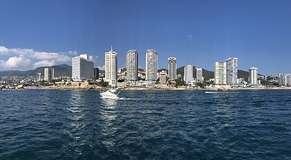 Acapulco, Guerrero's largest municipality by population
 -
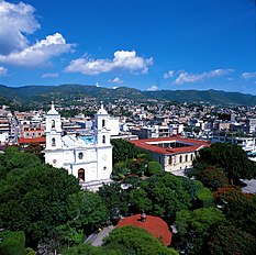 Chilpancingo, Guerrero's capital and second-largest municipality
 -
 Iguala, third largest municipality in Guerrero
 -
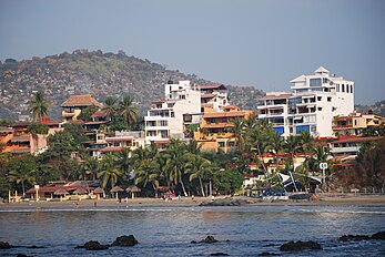 Zihuatanejo, Guerrero's fourth largest municipality

.jpg)


†
| Name | Municipal seat | Population (2020)[1] |
Population (2010)[7] |
Change | Land area[3] | Population density (2020) |
Incorporation date[8][a] | |
|---|---|---|---|---|---|---|---|---|
| km2 | sq mi | |||||||
Acapulco
|
Acapulco de Juárez | 779,566 | 789,971 | −1.3% | 1,733.61 | 669.35 | 449.7/km2 (1,164.7/sq mi) | August 6, 1824 |
Acatepec
|
Acatepec | 40,197 | 32,792 | +22.6% | 632.85 | 244.35 | 63.5/km2 (164.5/sq mi) | March 23, 1993 |
Ahuacuotzingo
|
Ahuacuotzingo | 25,205 | 25,027 | +0.7% | 874.14 | 337.51 | 28.8/km2 (74.7/sq mi) | 1826 |
Ajuchitlán
|
Ajuchitlán del Progreso | 37,655 | 38,203 | −1.4% | 2,000.88 | 772.55 | 18.8/km2 (48.7/sq mi) | 1826 |
Alcozauca
|
Alcozauca de Guerrero | 21,225 | 18,971 | +11.9% | 471.45 | 182.03 | 45.0/km2 (116.6/sq mi) | May 27, 1837 |
Alpoyeca
|
Alpoyeca | 7,813 | 6,637 | +17.7% | 94.18 | 36.36 | 83.0/km2 (214.9/sq mi) | May 27, 1837 |
| Apaxtla | Apaxtla de Castrejón | 11,112 | 12,389 | −10.3% | 628.88 | 242.81 | 17.7/km2 (45.8/sq mi) | April 30, 1924 |
Arcelia[b]
|
Arcelia | 33,267 | 32,181 | +3.4% | 756.47 | 292.07 | 44.0/km2 (113.9/sq mi) | March 23, 1861 |
Atenango del Río
|
Atenango del Río | 9,147 | 8,390 | +9.0% | 559.76 | 216.12 | 16.3/km2 (42.3/sq mi) | 1826 |
Atlamajalcingo del Monte
|
Atlamajalcingo del Monte | 5,811 | 5,706 | +1.8% | 147.00 | 56.76 | 39.5/km2 (102.4/sq mi) | May 27, 1837 |
Atlixtac
|
Atlixtac | 28,491 | 26,341 | +8.2% | 575.33 | 222.14 | 49.5/km2 (128.3/sq mi) | May 27, 1837 |
Atoyac
|
Atoyac de Álvarez | 60,680 | 61,316 | −1.0% | 1,454.17 | 561.46 | 41.7/km2 (108.1/sq mi) | November 29, 1880 |
Ayutla[c]
|
Ayutla de los Libres | 69,123 | 62,690 | +10.3% | 1,055.26 | 407.44 | 65.5/km2 (169.7/sq mi) | May 27, 1837 |
Azoyú
|
Azoyú | 15,099 | 14,429 | +4.6% | 397.31 | 153.40 | 38.0/km2 (98.4/sq mi) | May 27, 1837 |
Benito Juárez
|
San Jerónimo de Juárez | 15,442 | 15,019 | +2.8% | 230.71 | 89.08 | 66.9/km2 (173.4/sq mi) | January 1, 1934 |
Buenavista
|
Buenavista de Cuéllar | 12,982 | 12,688 | +2.3% | 304.93 | 117.73 | 42.6/km2 (110.3/sq mi) | January 17, 1934 |
Chilapa
|
Chilapa de Álvarez | 123,722 | 120,790 | +2.4% | 752.17 | 290.42 | 164.5/km2 (426.0/sq mi) | August 6, 1824 |
| Chilpancingo de los Bravo† | Chilpancingo de los Bravo | 283,354 | 241,717 | +17.2% | 2,187.80 | 844.72 | 129.5/km2 (335.4/sq mi) | 1826 |
| Coahuayutla de José María Izazaga | Coahuayutla de Guerrero | 12,408 | 13,025 | −4.7% | 2,653.49 | 1,024.52 | 4.7/km2 (12.1/sq mi) | November 29, 1880 |
Cochoapa el Grande
|
Cochoapa el Grande | 21,241 | 18,778 | +13.1% | 622.64 | 240.40 | 34.1/km2 (88.4/sq mi) | January 29, 1947 |
| Cocula | Cocula | 15,579 | 14,707 | +5.9% | 446.83 | 172.52 | 34.9/km2 (90.3/sq mi) | November 29, 1880 |
Copala
|
Copala | 14,463 | 13,636 | +6.1% | 297.57 | 114.89 | 48.6/km2 (125.9/sq mi) | October 6, 1869 |
Copalillo
|
Copalillo | 15,598 | 14,456 | +7.9% | 734.84 | 283.72 | 21.2/km2 (55.0/sq mi) | December 10, 1875 |
Copanatoyac
|
Copanatoyac | 21,648 | 18,855 | +14.8% | 307.63 | 118.78 | 70.4/km2 (182.3/sq mi) | November 29, 1880 |
Coyuca de Benítez
|
Coyuca de Benítez | 73,056 | 73,460 | −0.5% | 1,816.84 | 701.48 | 40.2/km2 (104.1/sq mi) | May 4, 1876 |
Coyuca de Catalán
|
Coyuca de Catalán | 38,554 | 42,069 | −8.4% | 3,368.20 | 1,300.47 | 11.4/km2 (29.6/sq mi) | December 10, 1831 |
Cuajinicuilapa[d]
|
Cuajinicuilapa | 26,627 | 25,922 | +2.7% | 633.77 | 244.70 | 42.0/km2 (108.8/sq mi) | April 1, 1852 |
Cualac
|
Cualac | 7,874 | 7,007 | +12.4% | 239.99 | 92.66 | 32.8/km2 (85.0/sq mi) | May 27, 1837 |
Cuautepec
|
Cuautepec | 17,024 | 15,115 | +12.6% | 315.04 | 121.64 | 54.0/km2 (140.0/sq mi) | May 27, 1837 |
Cuetzala del Progreso
|
Cuetzala del Progreso | 8,272 | 9,166 | −9.8% | 374.21 | 144.48 | 22.1/km2 (57.3/sq mi) | May 11, 1874 |
Cutzamala
|
Cutzamala de Pinzón | 20,537 | 21,388 | −4.0% | 1,339.79 | 517.30 | 15.3/km2 (39.7/sq mi) | 1826 |
| Eduardo Neri[e] | Zumpango del Río | 53,126 | 46,158 | +15.1% | 1,253.31 | 483.91 | 42.4/km2 (109.8/sq mi) | 1826 |
Florencio Villarreal[f]
|
Cruz Grande | 22,250 | 20,175 | +10.3% | 285.34 | 110.17 | 78.0/km2 (202.0/sq mi) | March 10, 1885 |
General Canuto A. Neri
|
Acapetlahuaya | 6,278 | 6,301 | −0.4% | 260.87 | 100.72 | 24.1/km2 (62.3/sq mi) | December 30, 1953 |
General Heliodoro Castillo[g]
|
Tlacotepec | 37,254 | 36,586 | +1.8% | 1,732.33 | 668.86 | 21.5/km2 (55.7/sq mi) | March 15, 1850 |
Huamuxtitlán
|
Huamuxtitlán | 17,488 | 14,393 | +21.5% | 275.81 | 106.49 | 63.4/km2 (164.2/sq mi) | May 27, 1837 |
| Huitzuco | Huitzuco de los Figueroa | 36,593 | 37,364 | −2.1% | 1,331.81 | 514.22 | 27.5/km2 (71.2/sq mi) | 1826 |
Iguala
|
Iguala de la Independencia | 154,173 | 140,363 | +9.8% | 572.50 | 221.04 | 269.3/km2 (697.5/sq mi) | 1826 |
Igualapa
|
Igualapa | 11,739 | 10,815 | +8.5% | 195.78 | 75.59 | 60.0/km2 (155.3/sq mi) | May 27, 1837 |
Iliatenco
|
Iliatenco | 11,679 | 10,522 | +11.0% | 241.06 | 93.07 | 48.4/km2 (125.5/sq mi) | November 25, 2005[10] |
Ixcateopan
|
Ixcateopan de Cuauhtémoc | 6,138 | 6,603 | −7.0% | 212.77 | 82.15 | 28.8/km2 (74.7/sq mi) | 1826 |
José Joaquín de Herrera
|
Hueycantenango | 18,381 | 15,678 | +17.2% | 132.41 | 51.12 | 138.8/km2 (359.5/sq mi) | November 10, 2002 |
Juan R. Escudero
|
Tierra Colorada | 26,093 | 24,364 | +7.1% | 410.16 | 158.36 | 63.6/km2 (164.8/sq mi) | December 26, 1953 |
| Juchitán | Juchitán | 7,559 | 7,166 | +5.5% | 254.64 | 98.32 | 29.7/km2 (76.9/sq mi) | March 5, 2004 |
| Las Vigas[h] | Las Vigas | — | — | — | — | — | — | August 31, 2021 |
| La Unión de Isidoro Montes de Oca[i] | La Unión | 26,349 | 25,712 | +2.5% | 1,765.85 | 681.80 | 14.9/km2 (38.6/sq mi) | August 6, 1824 |
| Leonardo Bravo | Chichihualco | 26,357 | 24,720 | +6.6% | 723.04 | 279.17 | 36.5/km2 (94.4/sq mi) | May 16, 1908 |
Malinaltepec[j]
|
Malinaltepec | 29,625 | 29,599 | +0.1% | 474.49 | 183.20 | 62.4/km2 (161.7/sq mi) | May 31, 1870 |
Marquelia
|
Marquelia | 14,280 | 12,912 | +10.6% | 211.45 | 81.64 | 67.5/km2 (174.9/sq mi) | June 15, 2002 |
| Mártir de Cuilapán[k] | Apango | 18,613 | 17,702 | +5.1% | 617.32 | 238.35 | 30.2/km2 (78.1/sq mi) | 1826 |
Metlatónoc
|
Metlatónoc | 18,859 | 18,976 | −0.6% | 603.60 | 233.05 | 31.2/km2 (80.9/sq mi) | May 27, 1837 |
Mochitlán
|
Mochitlán | 12,402 | 11,376 | +9.0% | 514.27 | 198.56 | 24.1/km2 (62.5/sq mi) | April 2, 1852 |
| Ñuu Savi[l] | Coapinola | — | — | — | — | — | — | August 31, 2021 |
Olinalá
|
Olinalá | 28,446 | 24,723 | +15.1% | 709.19 | 273.82 | 40.1/km2 (103.9/sq mi) | May 27, 1837 |
Ometepec
|
Ometepec | 68,207 | 61,306 | +11.3% | 604.68 | 233.47 | 112.8/km2 (292.1/sq mi) | March 20, 1824 |
| Pedro Ascencio Alquisiras | Ixcapuzalco | 7,076 | 6,978 | +1.4% | 295.15 | 113.96 | 24.0/km2 (62.1/sq mi) | November 28, 1890 |
Petatlán
|
Petatlán | 44,583 | 44,979 | −0.9% | 1,978.09 | 763.74 | 22.5/km2 (58.4/sq mi) | April 1, 1870 |
Pilcaya
|
Pilcaya | 12,753 | 11,558 | +10.3% | 162.79 | 62.85 | 78.3/km2 (202.9/sq mi) | December 10, 1931 |
Pungarabato
|
Ciudad Altamirano
|
38,482 | 37,035 | +3.9% | 126.72 | 48.93 | 303.7/km2 (786.5/sq mi) | December 10, 1831 |
Quechultenango
|
Quechultenango | 36,143 | 34,728 | +4.1% | 848.28 | 327.52 | 42.6/km2 (110.4/sq mi) | 1826 |
San Luis Acatlán
|
San Luis Acatlán | 46,270 | 42,360 | +9.2% | 1,101.36 | 425.24 | 42.0/km2 (108.8/sq mi) | November 29, 1880 |
| San Marcos[m] | San Marcos | 50,124 | 48,501 | +3.3% | 1,160.38 | 448.03 | 43.2/km2 (111.9/sq mi) | 1826 |
San Miguel Totolapan
|
San Miguel Totolapan | 24,139 | 28,009 | −13.8% | 2,378.57 | 918.37 | 10.1/km2 (26.3/sq mi) | June 23, 1871 |
| San Nicolás[n] | San Nicolás | — | — | — | — | — | — | August 31, 2021 |
| Santa Cruz del Rincón[o] | Santa Cruz del Rincón | — | — | — | — | — | — | August 31, 2021 |
Taxco
|
Taxco de Alarcón
|
105,586 | 104,053 | +1.5% | 652.73 | 252.02 | 161.8/km2 (419.0/sq mi) | August 6, 1824 |
Tecoanapa
|
Tecoanapa | 46,063 | 44,079 | +4.5% | 699.86 | 270.22 | 65.8/km2 (170.5/sq mi) | July 3, 1874 |
Tecpan
|
Tecpan de Galeana | 65,237 | 62,071 | +5.1% | 2,854.47 | 1,102.12 | 22.9/km2 (59.2/sq mi) | October 13, 1811 |
Teloloapan
|
Teloloapan | 53,817 | 53,769 | +0.1% | 1,012.59 | 390.96 | 53.1/km2 (137.7/sq mi) | 1826 |
Tepecoacuilco de Trujano
|
Tepecoacuilco de Trujano | 30,806 | 30,470 | +1.1% | 855.63 | 330.36 | 36.0/km2 (93.3/sq mi) | 1826 |
Tetipac
|
Tetipac | 13,552 | 13,128 | +3.2% | 218.48 | 84.36 | 62.0/km2 (160.7/sq mi) | July 1, 1872 |
Tixtla
|
Tixtla de Guerrero
|
43,171 | 40,058 | +7.8% | 389.90 | 150.54 | 110.7/km2 (286.8/sq mi) | August 6, 1824 |
Tlacoachistlahuaca
|
Tlacoachistlahuaca | 22,781 | 21,306 | +6.9% | 805.48 | 311.00 | 28.3/km2 (73.3/sq mi) | May 11, 1872 |
Tlacoapa[p]
|
Tlacoapa | 10,092 | 9,967 | +1.3% | 280.90 | 108.45 | 35.9/km2 (93.1/sq mi) | May 27, 1837 |
Tlalchapa
|
Tlalchapa | 11,681 | 11,495 | +1.6% | 473.52 | 182.83 | 24.7/km2 (63.9/sq mi) | October 20, 1851 |
Tlalixtaquilla
|
Tlalixtaquilla de Maldonado | 7,602 | 7,096 | +7.1% | 117.83 | 45.50 | 64.5/km2 (167.1/sq mi) | December 13, 1944 |
Tlapa
|
Tlapa de Comonfort | 96,125 | 81,419 | +18.1% | 611.02 | 235.91 | 157.3/km2 (407.5/sq mi) | March 20, 1824 |
Tlapehuala
|
Tlapehuala | 22,209 | 21,819 | +1.8% | 285.60 | 110.27 | 77.8/km2 (201.4/sq mi) | November 5, 1947 |
Xalpatlahuac
|
Xalpatlahuac | 11,966 | 12,240 | −2.2% | 227.38 | 87.79 | 52.6/km2 (136.3/sq mi) | November 29, 1880 |
Xochihuehuetlan
|
Xochihuehuetlan | 7,862 | 7,079 | +11.1% | 262.46 | 101.33 | 30.0/km2 (77.6/sq mi) | May 27, 1837 |
Xochistlahuaca
|
Xochistlahuaca | 29,891 | 28,089 | +6.4% | 454.74 | 175.58 | 65.7/km2 (170.2/sq mi) | May 27, 1837 |
Zapotitlán Tablas
|
Zapotitlán Tablas | 12,004 | 10,516 | +14.1% | 229.11 | 88.46 | 52.4/km2 (135.7/sq mi) | March 25, 1870 |
Zihuatanejo de Azueta[q]
|
Zihuatanejo | 124,824 | 118,211 | +5.6% | 1,472.67 | 568.60 | 84.8/km2 (219.5/sq mi) | December 23, 1953 |
| Zirándaro | Zirándaro de los Chávez
|
18,031 | 18,813 | −4.2% | 2,151.64 | 830.75 | 8.4/km2 (21.7/sq mi) | December 10, 1831 |
Zitlala
|
Zitlala | 21,977 | 22,587 | −2.7% | 305.66 | 118.02 | 71.9/km2 (186.2/sq mi) | 1826 |
| Guerrero | — | 3,540,685 | 3,388,768 | +4.5% | 63,803.42 | 24,634.64 | 55.5/km2 (143.7/sq mi) | — |
| Mexico | — | 126,014,024 | 112,336,538 | +12.2% | 1,960,646.7 | 757,010 | 64.3/km2 (166.5/sq mi) | — |
Notes
- ^ Incorporation years are included when there is no known primary source information on the date of amalgamation.[8]
- ^ Arcelia was originally incorporated as Totoltepec; it changed its name to Ixcatepec in 1874 and then to Arcelia on November 3, 1892.[8]
- ^ The municipality of Ñuu Savi was created from 37 localities in Ayutla on August 31, 2021, and the consequent change in population of 11,099 residents and land area is not reflected in the 2020 and 2010 census data.[9][2]
- ^ The municipality of San Nicolás was created from 10 localities in Cuajinicuilapa on August 31, 2021, and the consequent change in population of 6,948 residents and land area is not reflected in the 2020 and 2010 census data.[9][2]
- ^ Eduardo Neri was originally incorporated as Zumpango del Río; it changed its name on October 13, 1987.[8]
- ^ Florencio Villarreal was originally incorporated as Cruz Grande and changed its name on November 11, 1899.[8]
- ^ General Heliodoro Castillo was originally incorporated as Tlacotepec and changed its name on December 10, 1947.[8]
- ^ The municipality of Las Vigas was created from 19 localities in San Marcos on August 31, 2021, and this change is not included in the 2020 or 2010 census figures. The population of Las Vigas is 9,449 as of the 2020 census.[9][2]
- ^ La Unión was originally incorporated as Zacatula; it changed its name to La Unión de Isidoro Montes de Oca on November 29, 1880.[8]
- ^ The municipality Santa Cruz del Rincón was created from 19 localities in Malinaltepec on August 31, 2021, and the consequent change in population of 6,851 residents and land area is not reflected in the 2020 and 2010 census data.[9][2]
- ^ Arcelia was originally incorporated as Apango; it changed its name to Atliaca in May 23, 1874 and then to Mártir de Cuilapán on November 27, 1926.[8]
- ^ The municipality of Ñuu Savi was created from 37 localities in Ayutla on August 31, 2021, and this change is not included in the 2020 or 2010 census figures. Ñuu Savi has a population of 11,099 as of the 2020 census.[9][2]
- ^ The municipality of Las Vigas was created from 19 localities in San Marcos on August 31, 2021, and the consequent change in population of 9,449 residents and land area is not reflected in the 2020 and 2010 census data.[9][2]
- ^ The municipality of San Nicolás was created from 10 localities in Cuajinicuilapa on August 31, 2021, and this change is not included in the 2020 or 2010 census figures. The population of is 6,948 as of the 2020 census.[9][2]
- ^ The municipality of Santa Cruz del Rincón was created from 19 localities in Malinaltepec on August 31, 2021, and this change is not included in the 2020 or 2010 census figures. The population of Santa Cruz del Rincón is 6,851 as of the 2020 census.[9][2]
- ^ Tlacoapa was originally incorporated as Totomixtlahuaca and changed its name to Tlacoapa on May 30, 1885.[8]
- ^ Zihuatanejo was originally incorporated as José Azueta; it changed its name to Zihuatanejo de Azueta on May 6, 2008.[11]
References
- ^ a b c d "Censo de Población y Vivienda 2020– SCITEL" (in Spanish). INEGI. Archived from the original on January 26, 2021. Retrieved January 27, 2021.
- ^ a b c d e f g h i Castro Ortiz, Leticia (January 13, 2022). "Aprueba Congreso Incorporar 4 Nuevos Municipios a la Constitución de Guerrero". congresogro.gob.mx. Congreso del Estado de Guerrero. Archived from the original on November 13, 2023. Retrieved December 16, 2023.
- ^ a b c "México en cifras–Medio Ambiente–Querétaro" (in Spanish). INEGI. Archived from the original on March 7, 2023. Retrieved February 12, 2021.
- ^ Constitución Política de los Estados Unidos Mexicanos (Article 115) (in Spanish). 1917. Retrieved September 27, 2017. Archived February 21, 2018, at the Wayback Machine
- ISBN 9264015329. Archivedfrom the original on October 9, 2023. Retrieved September 20, 2020.
- ^ ISBN 9781433070303.
- ^ "Censo de Población y Vivienda 2010–SCITEL" (in Spanish). INEGI. Archived from the original on February 13, 2021. Retrieved January 27, 2021.
- ^ ISBN 970-13-1491-3. Archived(PDF) from the original on November 5, 2023. Retrieved February 2, 2021.
- ^ a b c d e f g h Rosario García (August 31, 2021). "Aprueba el Congreso de Guerrero la creación de 4 nuevos municipios". El Financiero. Archived from the original on November 13, 2023. Retrieved November 18, 2023.
- ^ "Iliatenco". Enciclopedia de los Municipios de México. Instituto Nacional para el Federalismo y el Desarrollo Municipal. Archived from the original on June 17, 2011. Retrieved December 23, 2008.
- ^ "Brief description of the City & Municipality Government". www.ixtapa-zihuatanejo.com. Ixtapa Zihuatanejo - Government of the City (Municipality) and State. Archived from the original on December 17, 2023. Retrieved December 16, 2023.