
Nan, Thailand
This article is written like a encyclopedic style or move the content to Wikivoyage . (October 2014) |
Nan
น่าน ᨶᩣ᩠᩵ᨶ | |
|---|---|
UTC+7 (ICT ) |
Nan (
| Nan, Thailand | |
|---|---|
 | |
| Thai name | |
| Thai | น่าน |
| RTGS | Nan |
| Northern Thai name | |
| Northern Thai | ᨶᩣ᩠᩵ᨶ (Nan) |
History
Nan for centuries was a separate, autonomous kingdom with few relationships with the outside world. There is evidence of prehistoric habitation, but it wasn't until several small mueang united to form Nanthaburi on the Nan River in the mid-14th century, contemporaneously with the creation of Luang Prabang and the Lan Xang (Million Elephants) kingdom in Laos, that the city became notable. Associated with the Sukhothai Kingdom, the mueang took the title Wara Nakhon and played a significant part in the development of early Thai nationalism.
By the end of the 14th century Nan was one of the nine northern Thai-Lao principalities that formed
The
Parts of the old city wall and several early
Climate
| Climate data for Nan (1991–2020) | |||||||||||||
|---|---|---|---|---|---|---|---|---|---|---|---|---|---|
| Month | Jan | Feb | Mar | Apr | May | Jun | Jul | Aug | Sep | Oct | Nov | Dec | Year |
| Record high °C (°F) | 36.8 (98.2) |
38.8 (101.8) |
41.8 (107.2) |
44.1 (111.4) |
42.5 (108.5) |
40.3 (104.5) |
38.0 (100.4) |
38.4 (101.1) |
36.3 (97.3) |
36.6 (97.9) |
36.7 (98.1) |
35.3 (95.5) |
44.1 (111.4) |
| Mean daily maximum °C (°F) | 30.8 (87.4) |
33.6 (92.5) |
36.3 (97.3) |
37.0 (98.6) |
35.5 (95.9) |
34.0 (93.2) |
32.7 (90.9) |
32.2 (90.0) |
32.9 (91.2) |
32.8 (91.0) |
31.8 (89.2) |
30.1 (86.2) |
33.3 (92.0) |
| Daily mean °C (°F) | 21.8 (71.2) |
23.9 (75.0) |
27.1 (80.8) |
29.1 (84.4) |
29.0 (84.2) |
28.7 (83.7) |
27.9 (82.2) |
27.4 (81.3) |
27.4 (81.3) |
26.7 (80.1) |
24.5 (76.1) |
21.8 (71.2) |
26.3 (79.3) |
| Mean daily minimum °C (°F) | 14.9 (58.8) |
16.1 (61.0) |
19.4 (66.9) |
22.6 (72.7) |
24.0 (75.2) |
24.4 (75.9) |
24.2 (75.6) |
23.9 (75.0) |
23.7 (74.7) |
22.3 (72.1) |
19.1 (66.4) |
15.5 (59.9) |
20.8 (69.5) |
| Record low °C (°F) | 3.5 (38.3) |
7.0 (44.6) |
9.1 (48.4) |
17.4 (63.3) |
18.5 (65.3) |
20.1 (68.2) |
19.6 (67.3) |
19.4 (66.9) |
19.4 (66.9) |
13.4 (56.1) |
6.2 (43.2) |
2.7 (36.9) |
2.7 (36.9) |
| Average precipitation mm (inches) | 14.3 (0.56) |
8.8 (0.35) |
38.7 (1.52) |
98.0 (3.86) |
170.2 (6.70) |
134.8 (5.31) |
213.3 (8.40) |
291.5 (11.48) |
206.2 (8.12) |
59.8 (2.35) |
15.8 (0.62) |
12.1 (0.48) |
1,263.5 (49.74) |
| Average precipitation days (≥ 1.0 mm) | 1.3 | 0.8 | 3.2 | 6.7 | 11.3 | 11.5 | 15.1 | 17.9 | 13.9 | 6.9 | 1.4 | 0.8 | 90.8 |
| Average relative humidity (%)
|
75.8 | 69.0 | 64.7 | 67.6 | 74.7 | 78.3 | 81.5 | 84.4 | 84.0 | 81.3 | 78.8 | 77.4 | 76.5 |
| Mean monthly sunshine hours | 272.8 | 257.1 | 294.5 | 243.0 | 198.4 | 156.0 | 120.9 | 117.8 | 144.0 | 201.5 | 216.0 | 254.2 | 2,476.2 |
| Mean daily sunshine hours | 8.8 | 9.1 | 9.5 | 8.1 | 6.4 | 5.2 | 3.9 | 3.8 | 4.8 | 6.5 | 7.2 | 8.2 | 6.8 |
| Source 1: World Meteorological Organization[4] Feb–May record highs and lows 1951–2022;[5] [6] | |||||||||||||
| Source 2: Office of Water Management and Hydrology, Royal Irrigation Department (sun 1981–2010)[7](extremes)[8] | |||||||||||||
Culture
Wat Phumin is the city's most well-known wat. It is located near the Nan National Museum.[9] The fifteenth century Wat Phra That Khao Noi overlooks the city and the golden Phra Buddha Maha Udom Mongkhon Nanthaburi, Sri Nan is enshrined there.[10] The city has a lak muang (city pillar), Wat Ming Mueang, at the center of the city.[11][12]
Gallery
-
 The standing Buddha of Wat Phra That Khao Noi overlooks Nan
 -
 Chao Fongkham House balcony
 -

-
 Murals of Wat Phumin
 -
 Wat Phra That Chang Kham
 -
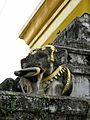 Gilded elephant heads of the chedi, Wat Phra That Chang Kham
 -
 Hariphunchai-style chedi, Wat Phaya Wat


References
- ^ "Nan Airport (NNT), Nan, Thailand". LatLong.net. Retrieved 2018-12-27.
- ^ รายงานสถิติจำนวนประชากรและบ้าน ประจำปี พ.ศ. 2560 ท้องถิ่นเทศบาลเมืองน่าน ระบบสถิติทางการทะเบียน กรมการปกครอง
- ^ "Nan". Tourism Authority of Thailand (TAT). Retrieved 18 May 2015.
- ^ "World Meteorological Organization Climate Normals for 1991–2020". World Meteorological Organization. Retrieved 12 October 2023.
- ^ Thai Meteorological Department. "สถิติอุณหภูมิสูงที่สุดในช่วงฤดูร้อนของประเทศไทยระหว่าง พ.ศ. 2494 - 2565" [Extreme maximum temperature during summer season in Thailand (1951 - 2022)] (PDF). TMD website. Retrieved 19 March 2023.
- ^ Thai Meteorological Department. "Extreme minimum temperature during winter season in Thailand 71 year period (1951 - 2021);" (PDF). TMD website. Retrieved 19 March 2023.
- ^ "ปริมาณการใช้น้ำของพืชอ้างอิงโดยวิธีของ Penman Monteith (Reference Crop Evapotranspiration by Penman Monteith)" (PDF) (in Thai). Office of Water Management and Hydrology, Royal Irrigation Department. p. 22. Retrieved 31 July 2016.
- ^ "Climatological Data for the Period 1981–2010". Thai Meteorological Department. Retrieved 4 August 2016.
- ^ "Wat Phumin". www.tourismthailand.org. Retrieved 2022-09-05.
- ^ Admin (2020-12-26). "Wat Phra That Khao Noi | Nan Province | Travel in Nan Thailand". Nan Province. Retrieved 2022-09-05.
- ^ orientalarchitecture.com. "City Pillar (Lak Muang), Nan, Thailand". Asian Architecture. Retrieved 2022-09-14.
- ^ "Wat Ming Mueang". www.tourismthailand.org. Retrieved 2022-09-14.
Further reading
- Ratchasomphan (Sænluang) (1994). ISBN 0-87727-715-X.
External links
 Nan travel guide from Wikivoyage
- David K. Wyatt. "THE CHRONOLOGY OF NAN HISTORY, A.D.1320-1598" (PDF). siamese-heritage.org. Retrieved 9 July 2017.
- Tourism Authority of Thailand: Nan
- Oriental Architecture profile - photos of 12 sites in Nan with GPS calibrated map
| International | |
|---|---|
| National | |