
Nandaprayag
Nandaprayag | |
|---|---|
Town | |
UTC+5:30 (IST) | |
| PIN | 246449[1] |
Nandaprayag is a town and a
Geography
Nandaprayag is located at 30°20′N 79°20′E / 30.33°N 79.33°E. It has an average elevation of 1,358 metres (4,455 feet). The 538 km long
Demographics
As of 2001[update] India census,[3] Nandaprayag had a population of 1433. Males constitute 56% of the population and females 44%. Nandaprayag has an average literacy rate of 70%, higher than the national average of 59.5%: male literacy is 78%, and female literacy is 61%. In Nandaprayag, 13% of the population is under 6 years of age.
Hydro Electric Project
Uttarakhand Jalvidyut UJVN, a government of Uttarakhand enterprise, is working on the Bowala Nand Prayag Hydro Electric Power Project. The project with a proposed installation of 300 MW (4 x 75 MW) is envisaged to generate an annual energy generation of 1102 MU in a 90% dependable year.[4]
Salient Features
- Location - Chamoli district, Uttarakhand
- River – Alaknanda
- Capacity - 300 MW
- Barrage - 5 Nos. of gates of size 11.0 x 8.0 m
- Head Race Tunnel - 10.05 Km, 9.3 m dia Horse Shoe
- Surge shaft - 27 m dia underground restricted orifice of 80.0 m height
- Penstock - 4 Nos., 3.0 m dia, each
- Surface Power House - size 120m long x 22.2 m wide x 44 m high
- Generator 4 units of 75 MW each
- Francis Turbine - 4 Nos. of Vertical
- Rated head - 138.9 m
- Project land – 62.0 Ha
- Annual Generation - 1343.1 MU
- Project Cost - 2226.56 crores on Feb, 2015 PL
- Year of Commissioning/Completion Schedule - Dec 2022


Gallery
-
 Another view of the confluence of the Nandakini River (foreground) and theNandprayag
 -
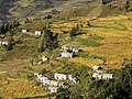 Bangali village nearNandprayag.


References
- ^ "Nandprayag Pin code". pin-code.net. Retrieved 31 July 2021.
- ISBN 81-291-0861-5. Page 12
- ^ "Census of India 2001: Data from the 2001 Census, including cities, villages and towns (Provisional)". Census Commission of India. Archived from the original on 16 June 2004. Retrieved 1 November 2008.
- ^ "Welcome to Uttarakhand Jalvidyut Nigam". Archived from the original on 4 August 2018. Retrieved 23 August 2016.
External links
This article related to a location in the Indian state of Uttarakhand is a stub. You can help Wikipedia by expanding it. |