
Nathalie, Virginia
Nathalie, Virginia | ||
|---|---|---|
GNIS feature ID1497035 | | |
Nathalie is an
2010 census was 183.[2]
Geography
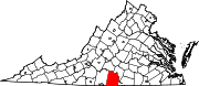
Located in northern Halifax County at 36°56′6″N 78°56′50″W / 36.93500°N 78.94722°W (36.9348619, −78.9472347), at an altitude of 524 feet (160 m), it lies along Road 603 15 miles (24 km) north of the town of
U.S. Census Bureau, the CDP has a total area of 3.0 square miles (7.8 km2), of which 0.02 square miles (0.06 km2), or 0.76%, are water.[2] The community is drained by tributaries of Catawba Creek, which flows northeast to the Roanoke River
at Clarkton.
History
It received its name in 1890 or 1891, being named after Natalie Otey (not "Nathalie"), daughter of Mrs. Rebecca Wimbish, an important local landowner.ZIP code of 24577.[5]
The former Clarkton Bridge over the Roanoke or "Staunton" River 4 miles (6 km) northeast of town was listed on the National Register of Historic Places in 2006.[6]
References
- ^ a b Rand McNally. The Road Atlas '09. Chicago: Rand McNally, 2009, p. 106.
- ^ a b "Geographic Identifiers: 2010 Census Summary File 1 (G001): Nathalie CDP, Virginia". American Factfinder. U.S. Census Bureau. Archived from the original on February 13, 2020. Retrieved March 21, 2018.
- ^ "Nathalie - Largest Rural Mail Route in the U.S." from 1974 article in the Gazette-Virginian by Hugh D. Koontz, II.
- ^ History of Nathalie, Virginia, based on information from History of Halifax (2 vols.), 1978, by Pocahontas Edmunds, ASIN: B0007AN8NO
- ^ Zip Code Lookup
- ^ "National Register Information System". National Register of Historic Places. National Park Service. July 9, 2010.
 | ||||
| CDPs | ||||
| Unincorporated communities | ||||
| Footnotes | ‡This populated place also has portions in an adjacent county or counties | |||
| ||||