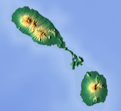
Nevis Peak
| Nevis Peak | |
|---|---|
 Nevis Peak in December 2011 | |
| Highest point | |
| Elevation | 985 m (3,232 ft)[1][2] |
| Prominence | 985 m (3,232 ft)[2] |
| Listing | Volcanoes in Saint Kitts and Nevis |
| Coordinates | 17°09′N 62°35′W / 17.15°N 62.58°W[1] |
| Geography | |
| Location | Saint Kitts and Nevis |
| Geology | |
| Mountain type | Stratovolcano |
| Volcanic arc | Lesser Antilles Volcanic Arc |
| Last eruption | unknown[1] |
Nevis Peak is a
volcanic activity
.
The steeper parts of Nevis Peak are impossible to farm. During the height of the island's exploitation, when every available scrap of
montane
habitat.
It is possible to
Leeward Island
chain.
The fauna of the mountain includes birds such as the
red-necked pigeon and the bridled quail-dove, as well as many troops of the African green vervet monkey, which was introduced in the historical past and has become naturalized. The flora of Nevis Peak includes five different kinds of tree fern, some Heliconia
species, and a number of small wild orchid species.
The five
parishes of Nevis
meet at the summit.
References
- ^ a b c d "Nevis Peak". Global Volcanism Program. Smithsonian Institution. Retrieved 2018-01-06.
- ^ a b "Nevis Peak, Saint Kitts and Nevis". Peakbagger.com. Retrieved 2011-12-19.
- Sources
- Ordnance Survey, Government of the United Kingdom 1984, Nevis, with part of St. Christopher (Saint Kitts). Series E803 (D.O.S. 343), Sheet NEVIS, Edition 5 O.S.D. 1984. Reprinted in 1995, published by the Government of the United Kingdom (Ordnance Survey) for the Government of Saint Christopher (St. Kitts) and Nevis.
- Robinson, David; Lowery, Jennifer, eds. (2000). The natural history of the island of Nevis. Ithaca, New York: Nevis Historical and Conservation Society Press.
- "Topographic map of Nevis Peak". opentopomap.org. Retrieved 2023-03-06.
Wikimedia Commons has media related to Nevis Peak.

