
Ben Nevis
| Ben Nevis | |
|---|---|
| Beinn Nibheis | |
Country high point | |
| Coordinates | 56°47′49″N 5°00′13″W / 56.79685°N 5.003508°W |
| Geography | |
 Ben Nevis Location within Scotland | |
| Location | Lochaber, Highland, Scotland |
| Parent range | Grampian Mountains |
| OS grid | NN166712 |
| Topo map | OS Landranger 41, Explorer 392[2] |
| Climbing | |
| First ascent | 19 August 1771, by James Robertson[3] |
| Easiest route | Pony track and mountain path |
Ben Nevis (
The mountain is a popular destination, attracting an estimated 150,000 visitors a year,
The summit is 1,345 metres (4,413 ft)
Ben Nevis is the namesake for a
.Etymology
The name comes from the
As with many
Geography
Ben Nevis forms a massif with its neighbours to the northeast, Càrn Mòr Dearg, to which it is linked by the Càrn Mòr Dearg Arête, Aonach Beag and Aonach Mòr.[2] All four are Munros.[13]
The western and southern flanks of Ben Nevis rise 1,200 metres (3,900 ft) in about 2 kilometres (1.2 mi) above the River Nevis flowing down Glen Nevis – the longest and steepest hill slope in Britain[14] – with the result that the mountain presents an aspect of massive bulk on this side. To the north, by contrast, cliffs drop some 600 metres (2,000 ft) to Coire Leis (IPA: [ˈkʰɔɾʲə ˈleʃ]).[2]
In addition to the main 1,345-metre (4,413 ft) summit, Ben Nevis has two subsidiary "tops" listed in
Summit
The summit of Ben Nevis comprises a large stony
The Peace Memorial, on the summit, is a cairn which was erected on
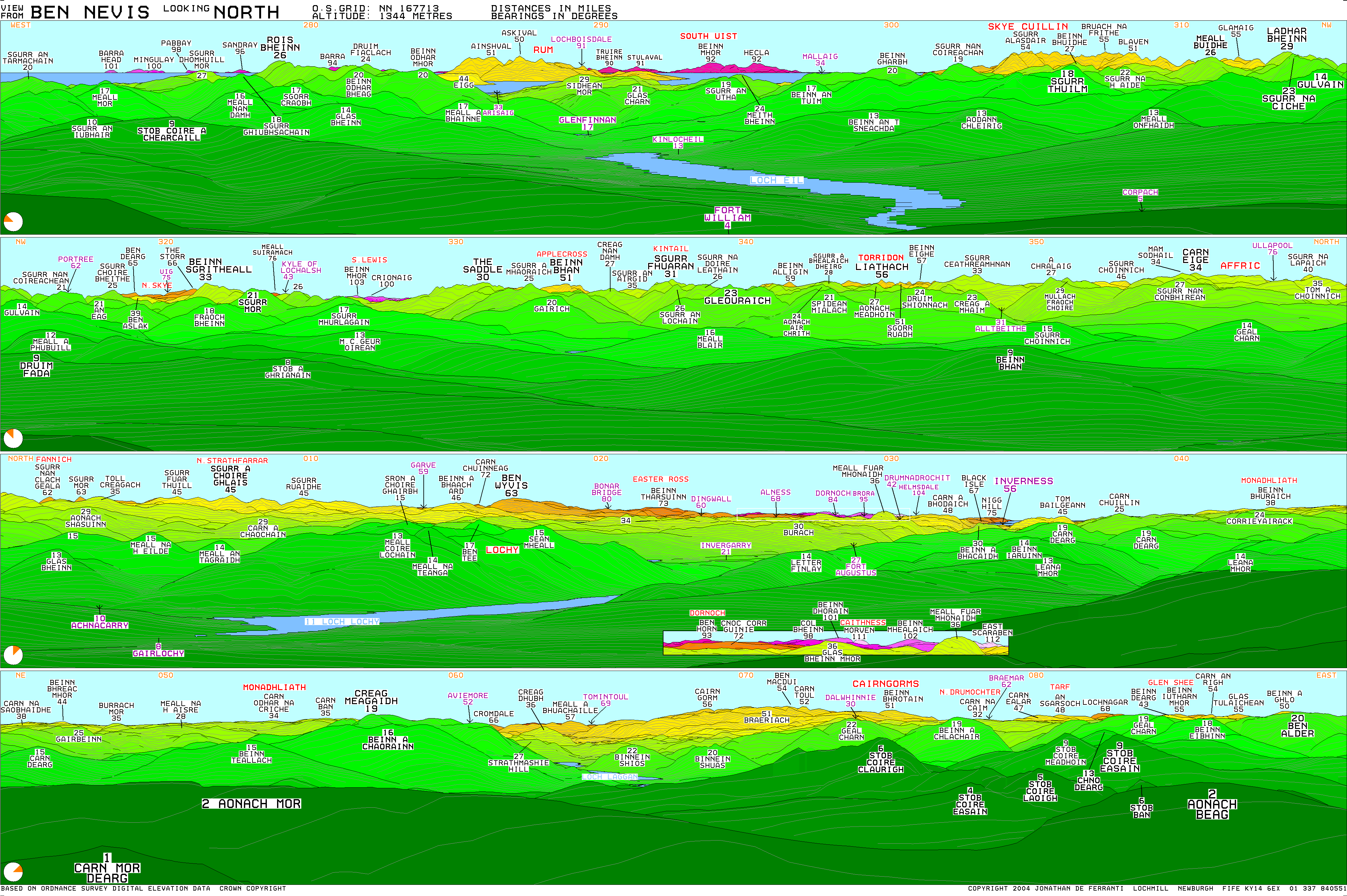
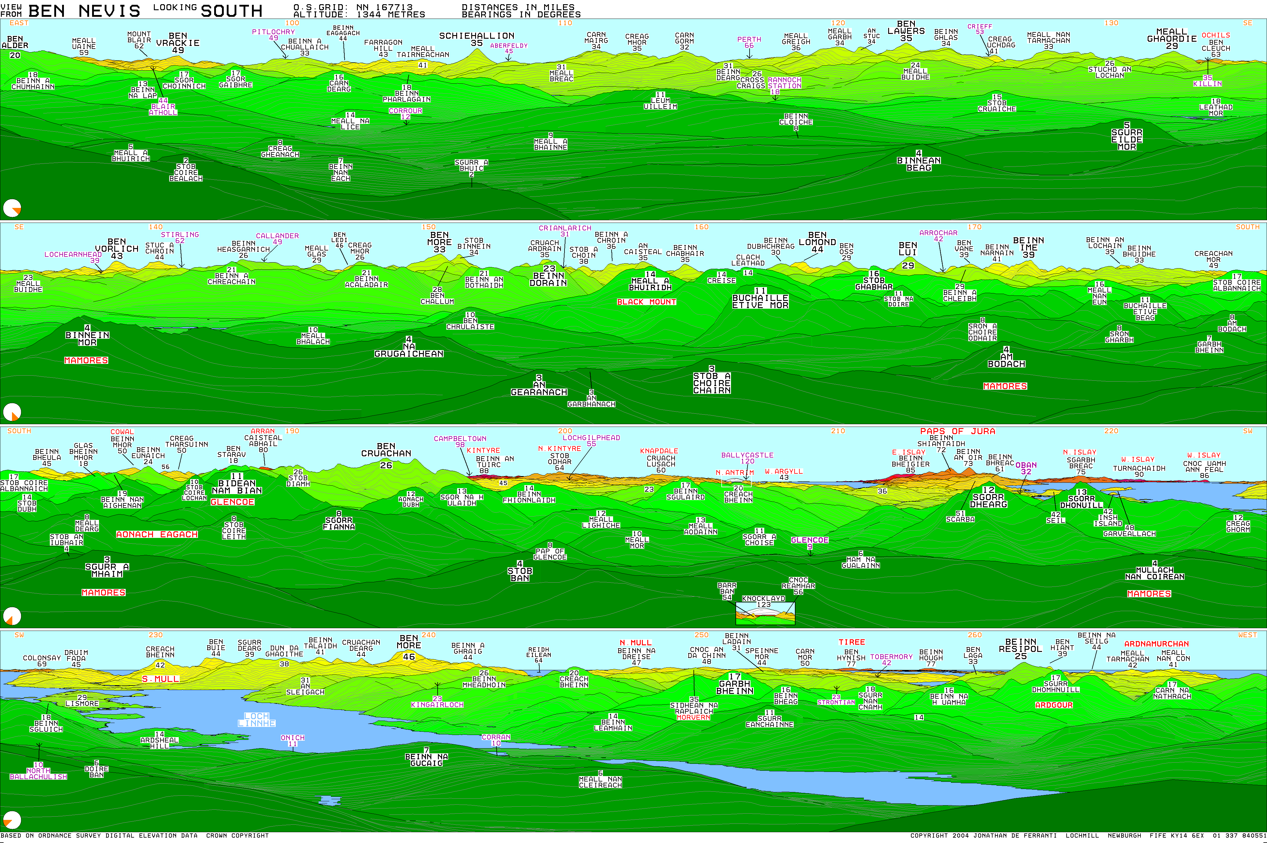
The view from the UK's highest point is extensive. Under ideal conditions, it can extend to over 190 kilometres (120 mi), including such mountains as the Torridon Hills, Morven in Caithness, Lochnagar, Ben Lomond, Barra Head and to Knocklayd in County Antrim, Northern Ireland.[23][24]
In 2016, the height of Ben Nevis was officially remeasured to be 1344.527m by Ordnance Survey. The height of Ben Nevis will therefore be shown on new Ordnance Survey maps as 1,345 metres (4,411 ft) instead of the now obsolete value of 1,344 metres (4,409 ft).[1]
Climate

Ben Nevis has a highland
| Climate data for Ben Nevis (1883-1904: during existence of summit observatory) | |||||||||||||
|---|---|---|---|---|---|---|---|---|---|---|---|---|---|
| Month | Jan | Feb | Mar | Apr | May | Jun | Jul | Aug | Sep | Oct | Nov | Dec | Year |
| Record high °C (°F) | 9.1 (48.4) |
7.8 (46.0) |
7.8 (46.0) |
11.4 (52.5) |
13.3 (55.9) |
19.1 (66.4) |
17.8 (64.0) |
17.5 (63.5) |
17.0 (62.6) |
14.0 (57.2) |
11.1 (52.0) |
7.2 (45.0) |
19.1 (66.4) |
| Mean daily maximum °C (°F) | −2.5 (27.5) |
−2.8 (27.0) |
−2.6 (27.3) |
−0.6 (30.9) |
2.6 (36.7) |
6.4 (43.5) |
7.1 (44.8) |
6.4 (43.5) |
5.4 (41.7) |
1.4 (34.5) |
0.1 (32.2) |
−1.9 (28.6) |
1.6 (34.9) |
| Daily mean °C (°F) | −4.4 (24.0) |
−4.6 (23.8) |
−4.4 (24.0) |
−2.4 (27.6) |
0.6 (33.0) |
4.3 (39.7) |
5.1 (41.1) |
4.7 (40.4) |
3.3 (38.0) |
−0.3 (31.4) |
−1.7 (28.9) |
−3.8 (25.2) |
−0.3 (31.4) |
| Mean daily minimum °C (°F) | −6.2 (20.8) |
−6.4 (20.5) |
−6.3 (20.7) |
−4.3 (24.3) |
−1.6 (29.1) |
2.1 (35.8) |
3.1 (37.6) |
2.9 (37.2) |
1.4 (34.5) |
−2.1 (28.2) |
−3.5 (25.7) |
−5.5 (22.1) |
−2.2 (28.0) |
| Record low °C (°F) | −17.4 (0.7) |
−16.8 (1.8) |
−15.8 (3.6) |
−11.5 (11.3) |
−9.8 (14.4) |
−5.1 (22.8) |
−3.2 (26.2) |
−2.8 (27.0) |
−7.6 (18.3) |
−9.8 (14.4) |
−12.1 (10.2) |
−13.8 (7.2) |
−17.4 (0.7) |
| Average precipitation mm (inches) | 469.8 (18.50) |
342.0 (13.46) |
378.9 (14.92) |
237.2 (9.34) |
204.4 (8.05) |
193.7 (7.63) |
269.8 (10.62) |
331.3 (13.04) |
391.6 (15.42) |
397.8 (15.66) |
394.8 (15.54) |
492.3 (19.38) |
4,103.8 (161.57) |
| Average precipitation days (≥ 1.0 mm) | 22.4 | 16.8 | 20.1 | 16.5 | 17.0 | 16.1 | 21.0 | 22.0 | 20.0 | 21.9 | 20.4 | 21.3 | 235.3 |
| Mean monthly sunshine hours | 22.4 | 42.3 | 54.7 | 80.4 | 116.3 | 127.0 | 84.8 | 58.1 | 62.3 | 41.8 | 27.8 | 18.0 | 735.9 |
| Percentage possible sunshine | 10 | 16 | 15 | 19 | 23 | 22 | 16 | 13 | 16 | 13 | 11 | 9 | 16 |
| Source 1: CEDA Archive[29] | |||||||||||||
| Source 2: Royal Society of Edinburgh (mean temp and sunshine 1884-1903)[30] | |||||||||||||
Geology
Ben Nevis is all that remains of a Devonian volcano that met a cataclysmic end in the Carboniferous period around 350 million years ago. Evidence near the summit shows light-coloured granite (which had cooled in subterranean chambers several kilometres beneath the surface) lies among dark basaltic lavas (that form only on the surface). The two lying side by side is evidence the huge volcano collapsed in on itself creating an explosion comparable to Thera (2nd millennium BC) or Krakatoa (1883).[31] The mountain is now all that remains of the imploded inner dome of the volcano.[32] Its form has been extensively shaped by
Research has shown
History
.jpg)
The first recorded ascent of Ben Nevis was made on 17 August 1771[36] by James Robertson, an Edinburgh botanist, who was in the region to collect botanical specimens. Another early ascent was in 1774 by John Williams, who provided the first account of the mountain's geological structure.[37] John Keats climbed the mountain in 1818, comparing the ascent to "mounting ten St. Pauls without the convenience of a staircase".[38] The following year William MacGillivray, who was later to become a distinguished naturalist, reached the summit only to find "fragments of earthen and glass ware, chicken bones, corks, and bits of paper".[39] It was not until 1847 that Ben Nevis was confirmed by the Ordnance Survey as the highest mountain in Britain and Ireland, ahead of its rival Ben Macdui.[40]
A meteorological observatory on the summit was first proposed by the Scottish Meteorological Society (SMS) in the late-1870s, at a time when similar observatories were being built around the world to study the weather at high altitude.[25] In the summer of 1881, Clement Lindley Wragge climbed the mountain daily to make observations (earning him the nickname "Inclement Rag"), leading to the opening on 17 October 1883 of a permanent observatory run by the SMS.[41] The building was staffed full-time until 1904, when it was closed due to inadequate funding. The twenty years worth of readings still provide the most comprehensive set of data on mountain weather in Great Britain.[25]
In September 1894,
The ruins of the observatory can still be seen on the summit.[44] An emergency shelter has been built on top of the observatory tower for the benefit of those caught out by bad weather.[45]
The first path to the summit was built at the same time as the observatory and was designed to allow ponies to carry up supplies, with a maximum gradient of one in five.[25] The opening of the path and the observatory made the ascent of the mountain increasingly popular, all the more so after the arrival of the West Highland Railway in Fort William in 1894.[46] Around this time the first of several proposals was made for a rack railway to the summit, none of which came to fruition.[38]
In 1911, an enterprising
In 2000, the Ben Nevis Estate, comprising all of the south side of the mountain including the summit, was bought by the Scottish conservation charity the John Muir Trust.[49][50]
On 17 May 2006, a piano that had been buried under one of the cairns on the peak was uncovered by the John Muir Trust, which owns much of the mountain.[51][52] The piano is believed to have been carried up for charity by removal men from Dundee over 20 years earlier.[53]
Outdoor recreation
Hiking and climbing

Ben Nevis is a popular hiking destination, with 150,000 people a year visiting the peak.[4]
The 1883 Pony Track to the summit (also known as the Ben Path, the Mountain Path or the Tourist Route) remains the simplest and most popular route of ascent. It begins at

A route popular with experienced
The north face of Ben Nevis is riven with buttresses, ridges, towers and pinnacles, and contains many classic scrambles and rock climbs. It is of major importance for British winter climbing, with many of its routes holding snow often until late April. It was one of the first places in Scotland to receive the attention of serious mountaineers; a partial ascent and, the following day, a complete descent of Tower Ridge in early September 1892 is the earliest documented climbing expedition on Ben Nevis.[57][58][59] (It was not climbed from bottom to top in entirety for another two years). The Scottish Mountaineering Club's Charles Inglis Clark hut was built below the north face in Coire Leis in 1929. Because of its remote location, it is said to be the only genuine alpine hut in Britain.[55]
Tower Ridge is the longest of the north face's four main
The north face contains dozens of graded rock climbs along its entire length, with particular concentrations on the Càrn Dearg Buttress (below the Munro top of Càrn Dearg NW) and around the North-east Buttress and Observatory Ridge. Classic rock routes include Rubicon Wall on Observatory Buttress (Severe) – whose second ascent in 1937, when it was considered the hardest route on the mountain, is described by W. H. Murray in Mountaineering in Scotland[14] – and, on Càrn Dearg, Centurion and The Bullroar (both HVS), Torro (E2), and Titan's Wall (E3), these four described in the SMC's guide as among "the best climbs of their class in Scotland".[62]

Many seminal lines were recorded before the
The north face is also one of Scotland's foremost venues for winter mountaineering and ice climbing and holds snow until quite late in the year; in a good year, routes may remain in winter condition until mid-spring. Most of the possible rock routes are also suitable as winter climbs, including the four main ridges; Tower Ridge, for example, is grade IV on the
In February 1960 James R. Marshall and Robin Clark Smith recorded six major new ice routes in only eight days including Orion Direct (V,5 400m); this winter version of Bell's Long Climb was "the climax of a magnificent week's climbing by Smith and Marshall, and the highpoint of the step-cutting era".[62]
Hill running

The history of
Regular races were organised until 1903, when two events were held; these were the last for 24 years, perhaps due to the closure of the summit observatory the following year.
The Ben Nevis Race has been run in its current form since 1937. It now takes place on the first Saturday in September every year, with a maximum of 500 competitors taking part.
Extreme sports
Ben Nevis is becoming popular with ski mountaineers and boarders. The Red Burn (Allt Coire na h-Urcaire) just to the North of the tourist path gives the easiest descent, but most if not all of the easier gullies on the North Face have been skied, as has the slope once adorned by the abseil poles into Coire Leis. No 4 gully is probably the most skied. Although Tower scoop makes it a no-fall zone, Tower Gully is becoming popular, especially in May and June when there is spring snow.[68]

In 2018 Jöttnar pro team member Tim Howell BASE jumped off Ben Nevis which was covered by BBC Scotland.[69]
On 6 May 2019, a team of highliners completed a crossing above the Gardyloo Gully, a new altitude record for the UK.[70] Also in May 2019, a team of 12, led by Dundee artist Douglas Roulston carried a 1.5-metre (4.9-foot) tall statue of the DC Thomson character Oor Wullie to the top of the mountain. The statue, which had been painted by Roulston with a 360-degree scene of the view from the summit was later sold at the Oor Wullie Big Bucket Trail charity auction to raise money for a number of Scottish children's charities.[71][72]
Ben Nevis is one of the three mountains climbed in the National Three Peaks Challenge, where participants aim to climb Ben Nevis, Scafell Pike and Snowdon, often within 24 hours and using motor transport between them. The total height climbed is 3,064 m (10,052 ft) and the distance walked 23 miles (37 km), with about 460 miles (740 km) of driving.[73] It has been estimated that some 30,000 people attempt the challenge each year, often as part of organised groups, and the impact on the local areas has been criticised.[74] Various records have been set for the challenge, including James Forrest's fastest self-supported completion in 16 days, 13 hours, 59 mins in 2021[75] and Imogen Boddy's fastest female completion on foot, with support, in 6 days 5 hours 43 mins, in 2024.[76] In 2022 the Nevis Landscape Trust introduced a registration system for charity events on Ben Nevis.[77][78]
Safety
Ben Nevis's popularity, climate and complex topography contribute to a high number of mountain rescue incidents. In 1999 there were 41 rescues and four fatalities on the mountain.[5] It has also been estimated that there are several deaths annually on Ben Nevis.[79]
Two avalanches occurred on Ben Nevis in 2009[80] and 2016,[81] causing the deaths of two people on each occasion. In another two avalanches that occurred in 1970[82] and 2019,[83] three people died on each occasion. A climber died in an avalanche on the north face of the mountain in 2022.[84]
Navigation
Some incidents arise over difficulties in navigating to or from the summit,[85] especially in poor visibility. The problem stems from the fact that the summit plateau is roughly kidney-shaped and surrounded by cliffs on three sides; the danger is particularly accentuated when the main path is obscured by snow. Two precise compass bearings taken in succession are necessary to navigate from the summit cairn to the west flank, from where a descent can be made on the Pony Track in relative safety.[86]
In the late 1990s, Lochaber Mountain Rescue Team erected two posts on the summit plateau to assist walkers attempting the descent in foggy conditions. These posts were subsequently cut down by climbers, sparking controversy in mountaineering circles on the ethics of such additions.[85][87] Critics argued that cairns and posts are an unnecessary man-made intrusion into the natural landscape, which create a false sense of security and could lessen mountaineers' sense of responsibility for their own safety.[87]
In 2009, the Nevis Partnership moved and erected a number of 6-foot (1.8 m)-tall cairns on the summit plateau to aid navigation.[88] Subsequently, the John Muir Trust cleared a number of smaller informal cairns in 2016 which had been erected by visitors, which were seen as dangerous as they could confuse walkers using them for navigation.[89]
In popular culture
The
Ben Nevis was the name of a
A mountain in Svalbard is also named Ben Nevis, after the Scottish peak. It is 922 metres (3,025 feet) high and is south of the head of Raudfjorden, Albert I Land, in the northwestern part of the island of Spitsbergen.[96] Hung Fa Chai, a 489-metre (1,604-foot) hill in Northeast New Territories of Hong Kong was given the name Ben Nevis by British surveyors in 1901.[97]
Wee Ben Nevis was a character appearing in The Beano comic for a few years from 1974, drawn by Vic Neill,[98] in a feature described by Auberon Waugh as having "strong undertones of Scottish Nationalism by its untrue suggestion that Scotsmen have superhuman strength despite their diminutive stature".[99]
See also
- Holme Fen – The lowest point in the United Kingdom.
- Mountains and hills of Scotland
- National Three Peaks Challenge
- Northwest Spitsbergen National ParkNorway - includes a mountain called Ben Nevis. Its height is 918 metres (3,012 feet) and it is located at Northwest Spitsbergen National Park
- The Remarkables, New Zealand – mountain range containing a peak also called Ben Nevis
- Scottish Highlands
- Scafell Pike
- Snowdon
Notes
- ^ This is the distance to the mountain Melderskin in Norway.
- ^ a b c "Great Britain's tallest mountain is taller". Ordnance Survey. 18 March 2016. Retrieved 18 March 2016.
- ^ a b c d e f Ordnance Survey 2002
- ^ Mitchell, Ian R. (2004). Scotland's Mountains Before the Mountaineers. Luath Press Limited. p. 33.
- ^ a b Cox, David (26 March 2018). "The hidden history of the UK's highest peak". BBC.
- ^ a b The Nevis Working Party (2001). "Nevis Strategy" (PDF). Archived (PDF) from the original on 4 November 2006. Retrieved 5 November 2006.
- ^ "Isolation for Ben Nevis - Peakbagger.com". www.peakbagger.com.
- ^ MacBain, Alexander (1922). Place Names, Highlands and Islands of Scotland. Stirling: Eneas Mackay. p. 47.
- ^ a b Nicolaisen, W. F. H. (1959). "Notes on Scottish Place-Names (12) – Nevis". Scottish Studies. 3: 214–218.
- ^ Watson, William J. (1926). The History of the Celtic Place-Names of Scotland. Edinburgh and London: William Blackwood and Sons. p. 472.
- ISBN 0-7134-5234-X.
- ^ "Ben Nevis, or the 'Ben' as it is fondly known locally". Visit Fort William Ltd. Archived from the original on 18 October 2007. Retrieved 23 October 2007.
- ^ "Ben Nevis is almost always referred to by climbers as simply The Ben (Ben meaning Mountain)". The Ben Nevis Challenge. Archived from the original on 3 November 2007. Retrieved 23 October 2007.
- ^ "Mountain Search". Hill Bagging. Retrieved 2 November 2024.
- ^ a b c Murray 1977
- ISBN 978-0-907521-53-2.
- ^ "Ben Nevis". Encyclopædia Britannica. Retrieved 25 November 2006. (Subscription required for full access.)
- ^ Storer, Ralph (2015). 50 Shades of Hillwalking. United Kingdom: Luath Press Limited.
- ^ "Europe Peaks with 200 km of Isolation". Peakbagger. Retrieved 2 November 2024.
- ^ "Ben Nevis Peace Memorial". Imperial War Museums. Retrieved 27 October 2024. Includes images and transcriptions of the plaques
- ^ "Ben Nevis War Memorial". canmore.org.uk. Canmore. Retrieved 27 October 2024.
- ^ Moranne-Brown, Zyllah. "Dudley Climbers celebrate Ben Nevis success". Black Country Radio. Retrieved 27 October 2024.
- ^ "War breaks out over peace cairn". The Oban Times: Lochaber News. 9 November 2006. Archived from the original on 16 December 2007. Retrieved 27 October 2024.
- ^ "View from Ben Nevis looking North". Viewfinder Panoramas. Archived from the original on 29 September 2009. Retrieved 25 November 2006.
- ^ "View from Ben Nevis looking South". Viewfinder Panoramas. Archived from the original on 29 September 2009. Retrieved 25 November 2006.
- ^ a b c d e Marjorie Roy (2004). "The Ben Nevis Meteorological Observatory 1883–1904" (PDF). International Commission on History of Meteorology. Archived from the original (PDF) on 27 September 2007. Retrieved 27 November 2006.
- ^ a b Murray 1977, p. 221
- ISBN 978-1-85060-295-8.
- ^ "Fascinating Facts". Ben Nevis Visitor Centre. Highlife Highland. Retrieved 5 November 2024.
- ^ "Meteorological Observations taken from Ben Nevis and Fort William (1883 -1904)". Centre for Environmental Data Analysis. Retrieved 19 January 2023.
- ^ "Transactions of the Royal Society of Edinburgh: The Meteorology of the Ben Nevis Observations". Royal Society of Edinburgh. Retrieved 19 January 2023.
- ^ "How volcanoes shaped Britain's landscape". BBC News. 5 July 2012.
- ^ "Geology of Ben Nevis". ben-nevis.com. Retrieved 5 July 2012.
- ^ Averis, A. B. G.; Averis, A. M. (2005). "A survey of the vegetation of Ben Nevis Site of Special Scientific Interest and Special Area of Conservation, 2003–2004" (PDF). Scottish National Heritage Commissioned Report. 090. Archived from the original (PDF) on 16 July 2011. Retrieved 11 December 2006.
- ^ McKirdy, Alan; Gordon, John; Crofts, Roger (2007). Land of Mountain and Flood: The Geology and Landforms of Scotland. Edinburgh: Birlinn. pp. 114–116.
- ^ Gillen, Con (2003). Geology and landscapes of Scotland. Harpenden: Terra. p. 80.
- ISBN 978-0-7073-0734-3.
- ^ Suzanne Miller (2004). "Ben Nevis Geology". The Edinburgh Geologist. 43: 3–9.
- ^ a b Hodgkiss 1994, p. 117
- ISSN 2053-9851.
- ^ Abraham, George Dixon (1907). The Complete Mountaineer. United Kingdom: Methuen & Company. p. 232.
- ISBN 978-0907521167.
- ^ Nobel Foundation (1965). "C. T. R. Wilson Biography from Nobel Lectures, Physics 1922–1941, Elsevier Publishing Company, Amsterdam". Retrieved 27 November 2006.
- ^ YouTube. Archived from the original on 7 April 2011. Retrieved 18 March 2016.
- ^ "Ben Nevis Observatory - recording the weather at the highest point in Britain". Google Arts & Culture. Retrieved 2 November 2024.
- ^ "Ben Nevis Summit". ben-nevis.com.
- ^ (PDF) from the original on 9 October 2022. Retrieved 2 June 2009.
- ^ "Motoring over Ben Nevis". The British Film Institute. Retrieved 7 October 2022.
- ^ MacLennan, Chris (21 May 2018). "Bronze Ford Model T unveiled in Fort William". The Press and Journal. Aberdeen. Retrieved 7 October 2022.
- ^ "Who owns Scotland? The changing face of Scotland's landowners". BBC News. 21 May 2019. Retrieved 27 October 2024.
- ^ "Ben Nevis". www.johnmuirtrust.org. Retrieved 27 October 2024.
- ^ "Piano found on Britain's highest mountain". The Guardian. London. 17 May 2006. Retrieved 30 October 2016.
- ^ "New twist in Nevis music mystery". BBC News. 18 May 2006. Retrieved 22 June 2006.
- ^ "Trust names Ben Nevis 'piano men'". BBC News. 19 May 2006. Retrieved 15 August 2006.
- ^ a b Butterfield 1986, p. 97
- ^ a b Scottish Mountaineering Club website. "Charles Inglis Clark Memorial Hut (C.I.C.)". Archived from the original on 15 September 2007. Retrieved 12 November 2007.
- ^ Butterfield 1986, p. 98
- ^ "Alpine Notes" (PDF). Alpine Journal. 17: 520–521. 1895. Retrieved 6 March 2025.
- ^ ISBN 978-1-85284-393-9.
- ^ Hodgkiss 1994, p. 119
- ^ Hodgkiss 1994, p. 126
- ^ a b Crocket & Richardson 2009, p. 100
- ^ a b Richardson 2002, p. 53
- ^ "MacLeod's Boldest: Echo Wall". Alpinist.com. Retrieved 22 February 2006.
- ^ "Climbing on Ben Nevis". Scottish Climbing Archive. Archived from the original on 24 September 2006. Retrieved 26 October 2006.
- ^ "Ben Nevis Race – a brief history". Fort William Online. Archived from the original on 2 January 2007. Retrieved 25 November 2006.
- ^ a b "Ben Nevis Race". www.scottishhillracing.co.uk. Retrieved 2 January 2019.
- ^ Bob Kopac. "For Sport Alone: The Ben Nevis Race". MHRRC Online. Archived from the original on 3 June 2013. Retrieved 2 June 2009.
- ^ Kenny Biggin, Scottish Offpiste Skiing and Snowboarding: Nevis Range and Ben Nevis (Spean Bridge: Skimountain, 2013), pp. 64–84
- ^ "Base jumper Tim Howell leaps from Ben Nevis". BBC Scotland, 12 February 2019
- ^ "In pictures: UK's highest altitude highline completed on Ben Nevis". BBC News. BBC. 5 July 2019. Retrieved 6 July 2019.
- ^ Rooney, Richard (14 May 2019). "Oor Wullie on Ben Nevis: How a 'superstar' team united two Scottish icons for charity". The Courier. Retrieved 27 October 2024.
- ^ MacLennan, Chris (17 June 2019). "Oor Wullie statue which was taken to top of Ben Nevis finds new home in Inverness". Press and Journal. Retrieved 27 October 2024.
- ^ "National Three Peaks Challenge". Three Peaks Challenge Ltd. Retrieved 12 November 2024.
- ^ "The Three Peaks Challenge – what do you think?". services.thebmc.co.uk. British Mountaineering Club. 4 October 2013. Retrieved 12 November 2024.
- ^ Bailey, Dan (6 December 2021). "James Forrest on the Self-Supported 3 Peaks Record". www.ukhillwalking.com. Retrieved 12 November 2024.
- ^ Pilastro, Eleonora (26 June 2024). "UK runner completes National Three Peaks Challenge in less than a week". Guinness World Records. Retrieved 12 November 2024.
- ^ "Ben Nevis registration system for charity walks". BBC News. 4 October 2022. Retrieved 12 November 2024.
- ^ "Organised Events". www.nevislandscape.co.uk. Nevis Landscape Partnership. Retrieved 12 November 2024.
- ^ Arnette, Alan. "About Ben Nevis". Archived from the original on 3 July 2022. Retrieved 3 July 2022.
- ^ Carrell, Severin (30 December 2009). "Ben Nevis avalanche kills two climbers". The Guardian. Archived from the original on 3 July 2022.
- ^ "Missing Ben Nevis couple were hit by 'massive avalanche'". The Herald (Glasgow). 24 March 2016. Archived from the original on 4 July 2022. Retrieved 4 July 2022.
- ^ "Rescuer tells of horror as Glencoe avalanche kills three climbers: "There were hundreds of tons of snow"". The Scotsman. 25 January 2009. Archived from the original on 24 December 2013. Retrieved 23 December 2013.
- ^ Carrell, Severin (12 March 2019). "Ben Nevis avalanche kills three people". The Guardian. Archived from the original on 3 July 2022. Retrieved 3 July 2022.
- ^ "Bristol teacher killed in Ben Nevis avalanche". BBC News. 5 January 2023. Archived from the original on 5 January 2023. Retrieved 5 January 2023.
- ^ a b The Mountaineering Council of Scotland (1997). "Ben Nevis—The Future". Newsletter. 33.
- ^ "Navigation on Ben Nevis". www.mcofs.org.uk. Mountaineering Scotland. Retrieved 30 October 2016.
- ^ a b The Mountaineering Council of Scotland. "Summit Safety and Ben Nevis Cairns: The MCofS seeks a resolution" (also see sub-pages). Archived from the original on 27 September 2006. Retrieved 26 October 2006.
- ^ Nevis Partnership (14 October 2009). "Ben Nevis Navigation - Cairns Moved". UK Climbing.
- ^ Shute, Joe (6 March 2016). "The deadly secret of Ben Nevis's man-made cairns". Archived from the original on 12 January 2022.
- ^ "Ben Nevis Distillery". Archived from the original on 25 November 2006. Retrieved 25 November 2006.
- ^ "Ben Nevis". Edinburgh Malt Whisky Tour. Archived from the original on 10 October 2006. Retrieved 25 November 2006.
- ^ "Ben Nevis Distillery". Scotchwhisky.net. Archived from the original on 29 December 2006. Retrieved 25 November 2006.
- ^ "Ben Nevis ale". Archived from the original on 22 October 2007. Retrieved 11 December 2006.
- ^ Lammert, Ron (January 2010). "Texas Wendish Heritage Society: Brief History". Texas Wendish Heritage Society.
- ^ "Miramar Ship Index". Retrieved 18 March 2016.
- ^ "Place names in Norwegian polar areas". Norwegian Polar Institute. Retrieved 11 March 2009.
- ^ Pang, Diana (27 August 2023). "Around the world in a day with Hong Kong's street names". Hong Kong Free Press. Retrieved 5 November 2024.
- ISBN 978-1-5267-7786-7. Retrieved 5 November 2024 – via Google books.
- ISBN 978-1-4447-1151-6. Retrieved 5 November 2024 – via Google books.
Bibliography
- ISBN 978-0-906371-71-8.
- Crocket, Ken; Richardson, Simon (2009). Ben Nevis: Britain's Highest Mountain: 2nd Edition. The Scottish Mountaineering Trust. ISBN 978-1-907233-10-4.
- Hodgkiss, Peter (1994). The Central Highlands (5th ed.). Scottish Mountaineering Trust. pp. 116–134. ISBN 978-0-907521-44-0.
- ISBN 0-319-22641-7.
- ISBN 978-0-00-216813-7.
- Richardson, Simon (2002). Ben Nevis: Rock and Ice Climbs. The Scottish Mountaineering Trust. ISBN 978-0-907521-73-0.
External links
 Definitions from Wiktionary
 Media from Commons
 Travel information from Wikivoyage
- Ben Nevis Photo Tour – 57 images from the Car Park to the Summit and Back via the Tourist Trail
- Nevis Partnership Archived 26 June 2019 at the Wayback Machine – Environmental and visitor management in the Nevis area
- Computer generated digital panoramas from Ben Nevis: North South Archived 29 September 2009 at the Wayback Machine index
- Ben Nevis Webcam
- 360munros.co.uk - Ben Nevis 360° Virtual Tours
- Ben Nevis. Munros Table. Scottish Mountaineering Club.
 | Nevis range |  | |
|---|---|---|---|
| Mamores | |||
| Grey Corries | |||
| Alder/Ardverikie | |||
| Ossian/Treig | |||
List of Munros and Munro Tops in Scotland | |||
| Northern Highlands (20) |    | |
|---|---|---|
| Western Highlands (20) | ||
| Central and Eastern Highlands (13) | ||
| Southern Highlands (15) |
| |
| Islands (13) | ||
| Scottish Lowlands, England and Wales (13) | ||
| Republic of Ireland, Northern Ireland (25) | ||
| International | |
|---|---|
| National | |