
Nisqually River
| Nisqually River | |
|---|---|
Nisqually Indian Reservation, Fort Lewis | |
| Physical characteristics | |
| Source | Nisqually Glacier |
| • location | Mount Rainier |
| • coordinates | 46°47′39″N 121°44′54″W / 46.79417°N 121.74833°W[1] |
| • elevation | 4,809 ft (1,466 m)[2] |
Nisqually National Wildlife Refuge | |
• coordinates | 47°6′31″N 122°42′11″W / 47.10861°N 122.70306°W[1] |
• elevation | 0 ft (0 m) |
| Length | 81 mi (130 km) |
| Basin size | 517 sq mi (1,340 km2)[3] |
| Discharge | |
| • location | La Grande, WA[4] |
| • average | 1,460 cu ft/s (41 m3/s)[4] |
| • minimum | 460 cu ft/s (13 m3/s) |
| • maximum | 39,500 cu ft/s (1,120 m3/s) |
| Basin features | |
| Tributaries | |
| • left | Little Nisqually River |
| • right | Mashel River |

The Nisqually River /nɪˈskwɑːli/ is a river in west central Washington in the United States, approximately 81 miles (130 km) long. It drains part of the Cascade Range southeast of Tacoma, including the southern slope of Mount Rainier, and empties into the southern end of Puget Sound. Its outlet was designated in 1971 as the Nisqually Delta National Natural Landmark.
The Nisqually River forms the Pierce–Lewis county line, as well as the boundary between Pierce and Thurston counties.
Course
The river rises in southern
Below Elbe, the river flows northwest through the foothills, passes near
History
The Nisqually River is the traditional territorial center of the
Several bridges were built across the Nisqually River in the 20th century for automobile traffic. The northbound bridge that carries Interstate 5 near the river's mouth was opened in 1938 for U.S. Route 99 and was followed by a southbound span in 1968. The bridges use a filled causeway to cross the delta that altered the river's course and contributed to increased flood risks in the basin. A replacement for the causeway is estimated to cost $4.2 billion.[9]
In the 1960s and 1970s, the Nisqually pursued their fishing rights along the river, which were stated in the Treaty of Medicine Creek but had been ignored. Nisqually tribal members, acting in concert with the nearby
Ecology
"Nisqually-1", a specimen of Populus trichocarpa, grew on the bank of the Nisqually River. Its genome sequence was published in 2006.
Tributaries
- Van Trump Creek
- Paradise River
- Muck Creek
- Yelm Creek
- Tanwax Creek
- Ohop Creek
- Mashel River
- Little Nisqually River
- East Creek
- Mineral Creek
- Big Creek
- Kautz Creek
- Murray Creek
- Horn Creek
- Goat Creek
- Tahoma Creek
- Dead Horse Creek
- Pebble Creek
Cities and towns on the Nisqually
-
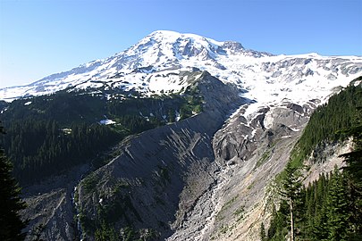 Mount Rainier and headwaters of the river from the Nisqually Glacier
 -

-
 The upper Nisqually River in Mount Rainier National Park
 -
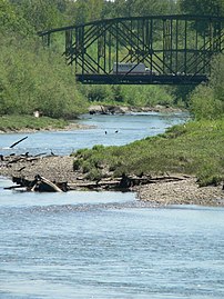 I-5 crosses the Nisqually River near its mouth


See also
- List of rivers in Washington
References
- ^ a b United States Geological Survey; U.S. Geological Survey Geographic Names Information System: Nisqually River; retrieved April 20, 2007.
- GNISsource coordinates. Retrieved April 20, 2007.
- ^ United States Geological Survey; Nisqually River at McKenna, WA; retrieved April 20, 2007.
- ^ a b United States Geological Survey; Nisqually River at La Grande, WA; retrieved April 20, 2007 (used instead of McKenna gage due to power canal river diversion).
- ^ "Nisqually River Project". Tacoma Power. Archived from the original on 2007-10-05. Retrieved 2009-05-20.
- ^ "National Registry of Natural Landmarks" (PDF). National Natural Landmarks Program. June 2009. p. 103. Archived from the original (PDF) on 2011-05-16. Retrieved 2014-08-13.
- ^ "Thurston County Place Names: A Heritage Guide" (PDF). Thurston County Historical Commission. 1992. p. 57. Retrieved March 28, 2018.
- ; retrieved on May 7, 2007.
- ^ Peterson, Josephine (September 30, 2022). "They cut costs in the '60s. Now part of I-5 faces flood danger or up to $4.2B to fix". The Olympian. Retrieved June 10, 2024.
- ^ George H. Boldt (1974). "The Boldt Decision" (PDF). United States District Court for the Western District of Washington, Tacoma Division. Archived from the original (PDF) on 2014-04-07. Retrieved 2014-12-04.
External links
- Nisqually River Council
- Nisqually Land Trust
- Nisqually River flooding information, Thurston County Emergency Management
| Authority control databases: National |
|---|