
Oban, Saskatchewan
Oban | |
|---|---|
Unincorporated area | |
Central Standard Time) | |
| [1][2][3][4] |
Oban is an
History
The name Oban is from the community
Economy
The community had a grain elevator and post office till the 1960s. The Oban Salt Company opened in 1937.[7]
Law and government
The Reeve and council of
Demographics
The population is enumerated as a part of the
| Population |
|---|
| Land area |
| Population density |
| Median age |
| Private dwellings |
| Median household income |
- N/A = Data Not Available
Education
Historically Oban School District #4733 was located at Township 37, Range 16 West of the 3rd Meridian.[10]
Transportation
In 1925 Oban was located on the Minnedosa–Saskatoon–Edmonton
Infrastructure
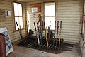
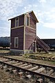
Oban had the last provincial interlocking tower at the Canadian National Railway and Canadian Pacific Railway level crossing which was constructed in 1910 and closed in 1990. The tower has been moved to the Saskatchewan Railway Museum.[6]
Oban tower was a requirement for the
There have been 8,800 miles (14,200 km) railway track in the province of Saskatchewan. Rail companies were intersected 58 times at level crossings. Some of these were railway lines crossing municipal street car rail lines. There were 36 Saskatchewan crossings which were controlled by mechanical interlocking machines between the early 1900s and 1990.[6]
Photo gallery
-
-

-
 Interlocking tower


See also
References
- ^ National Archives, Archivia Net, Post Offices and Postmasters, archived from the original on October 6, 2006
- ^ Government of Saskatchewan, MRD Home, Municipal Directory System, archived from the original on November 21, 2008
- ^ Canadian Textiles Institute. (2005), CTI Determine your provincial constituency, archived from the original on September 11, 2007
- ^ Commissioner of Canada Elections, Chief Electoral Officer of Canada (2005), Elections Canada On-line, archived from the original on April 21, 2007, retrieved October 7, 2008
- ^ "Biggar". communityprofiles saskbiz.ca. Government of Saskatchewan. Retrieved October 3, 2008.
- ^ a b c d "Welcome to Saskrailmuseum.org". GRAND TRUNK PACIFIC RAILWAY BUILDINGS. September 11, 2008. Archived from the original on October 15, 2008. Retrieved October 3, 2008.
- ^ ISBN 978-1-897010-19-8
- 2006 Canadian Census. Statistics Canada. August 20, 2019.
- 2001 Canadian Census. Statistics Canada. July 18, 2021.
- ^ Adamson, J. "– One Room School Project". Saskatchewan Gen Web. Retrieved October 3, 2008.
- ^ Adamson, J; et al. (July 23, 2007), Canadian Maps: January 1925 Waghorn's Guide. Post Offices in Man. Sask. Alta. and West Ontario. Online Historical Map Digitization Project
Further reading
- Title A Harvest of Memories: Oban, Neola, Avalon, Elwell, Monarch, Louvain, Kensmith, Twin Hill, Fairmount, Vanceview, Gagenville, Curths Hill, Castlewood, Whiteshore, Wilson Lake / [editor: Isla Solanik] or the North Biggar history
- Published Biggar, Sask.: North Biggar History Book Committee, 1986
- ISBN 0889256020
 Definitions from Wiktionary
 Media from Commons
 News from Wikinews
 Quotations from Wikiquote
 Texts from Wikisource
 Textbooks from Wikibooks
 Resources from Wikiversity
Places adjacent to Oban, Saskatchewan | ||||||||||||||||
|---|---|---|---|---|---|---|---|---|---|---|---|---|---|---|---|---|
| ||||||||||||||||
Subdivisions of Saskatchewan | |
|---|---|
| Subdivisions | |
| Communities | |
| Cities | |
| Topics | |