
Upper Palatinate
Upper Palatinate
Oberpfalz (German) | |
|---|---|
 Flag  Coat of arms | |
 Map of Bavaria highlighting Upper Palatinate | |
| Coordinates: 49°18′N 12°12′E / 49.3°N 12.2°E | |
| Country | Germany |
| State | Bavaria |
| Region seat | Regensburg |
| Government | |
| • District President | Walter Jonas |
| Area | |
| • Total | 9,692.23 km2 (3,742.19 sq mi) |
| Population (31 December 2022)[1] | |
| • Total | 1,133,741 |
| • Density | 120/km2 (300/sq mi) |
| GDP | |
| • Total | €51.234 billion (2021) |
| Website | regierung.oberpfalz.bayern.de |
The Upper Palatinate (German: Oberpfalz, pronounced [ˈoːbɐˌp͡falt͡s] ⓘ, Bavarian: Obapfoiz, Owerpfolz) is an administrative district in the east of Bavaria, Germany. It consists of seven districts and 226 municipalities, including three cities.
Geography
The Upper Palatinate is a landscape with low mountains and numerous ponds and lakes in its lowland regions. By contrast with other regions of Germany it is more rural in character and more sparsely settled. It borders (clockwise from the north) on Upper Franconia, the Czech Republic, Lower Bavaria, Upper Bavaria and Middle Franconia.
Notable regions are:
- Stiftland, former estate and territorial lordship of Waldsassen Abbey with the market town of Konnersreuth, Fockenfeld Abbey, the town of Waldsassen and about 150 other villages.
- Upper Palatine Forest with deep valleys and many castles
- Upper Palatine Lake District with the Steinberger See
- Upper Palatine Jura, part of the Franconian Jura
- Steinwald including the Teichelberg and Pechbrunn
- Waldnaab/Wondreb Depression
- Bavarian Forest, together with the Bohemian Forest a large-scale protected area. A rock outcrop west of the summit cross of the Großer Arber (1,455.5 m above sea level (NHN)) is 1,439.6 m, the highest point in Upper Palatinate.
- Kunisch Mountains
- Naab valley
- Vils valley
- Danube valley, western part of the Gäuboden[3]
- Lower Bavarian Hillssouth of the Danube
History
At the beginning of the
From the mid-13th century, much of the region was controlled by the
Cadet branches of the Wittelsbach dynasty also ruled over smaller territories in
After the founding of the Kingdom of Bavaria, the state was totally reorganised and, in 1808, divided into 15 administrative districts (German: Regierungsbezirke; singular Regierungsbezirk) called Kreise (literally "Circles", singular: Kreis). They were created in the fashion of the French departments, quite even in size and population, and named after their main rivers. In the following years, due to territorial changes (e.g. the loss of Tyrol, the addition of the Palatinate), the number of Kreise in the kingdom was reduced to 8. One of these was the Regenkreis (Regen District). In 1837, king Ludwig I of Bavaria renamed the Kreise after historical territorial names and tribes of the area. This also involved some border changes or territorial swaps. Thus, the district name of Regenkreis was changed to Upper Palatinate.
Districts
|
Landkreise (districts): |
Kreisfreie Städte (district-free towns):
|
Population
Historical Population of Upper Palatinate:
- 1900: 553,841
- 1910: 600,284
- 1939: 694,742
- 1950: 906,822
- 1961: 898,580
- 1970: 963,833
- 1987: 969,868
- 2002: 1,088,929
- 2005: 1,089,543
- 2006: 1,087,939
- 2008: 1,085,216
- 2010: 1,081,206
- 2015: 1,092,339
- 2019: 1,112,102
Economy
The gross domestic product (GDP) of the region was €47.3 billion in 2018, accounting for 1.4% of German economic output. GDP per capita adjusted for purchasing power was €39,200 or 130% of the EU27 average in the same year. The GDP per employee was 103% of the EU average.[4]
Main sights
Major tourist attractions include the former ducal residences
-
 Walhallamemorial
 -
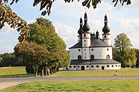 Trinity church of Kappl
 -
 Maria-Hilf


See also
References
- ^ Genesis Online-Datenbank des Bayerischen Landesamtes für Statistik Tabelle 12411-003r Fortschreibung des Bevölkerungsstandes: Gemeinden, Stichtag (Einwohnerzahlen auf Grundlage des Zensus 2011) (Hilfe dazu).
- ^ "EU regions by GDP, Eurostat". Retrieved 18 September 2023.
- ^ "BFN: Landschaftssteckbrief".
- ^ "Regional GDP per capita ranged from 30% to 263% of the EU average in 2018". Eurostat.
External links
- Official website (German)
- Official website of government (German, English, Czech)
- wiki-en.genealogy.net
Administrative regions (Regierungsbezirk) of Bavaria | |||
|---|---|---|---|
| Regions | |||
| Former region |
| ||
| International | |
|---|---|
| National | |
| Other | |