
Oder (Harz)
| Oder | |
|---|---|
 | |
 Southwest Harz with the Oder | |
| Location | |
| Country | Germany |
| State | East Lower Saxony |
| Physical characteristics | |
| Source | |
| • location | near Oderbrück (part of Sankt Andreasberg) in the Harz Mountains |
| • elevation | ca. 810 m above sea level (NN) |
Oder Reservoir | |
The Oder is a 56-kilometre-long (35 mi) river in Lower Saxony, Germany, and a right tributary of the Rhume. Its source is in the Harz mountains, near Sankt Andreasberg. It flows southwest through Bad Lauterberg, Pöhlde and Hattorf am Harz. The Oder flows into the Rhume in Katlenburg-Lindau.
Course
The Oder rises in the district of Goslar in the heart of the Harz Mountains. Its source is located in the southern part of the Brockenfeld about 1.3 km (0.81 mi) north of the Achtermannshöhe. The river's source is called the Odersprung or "Oder Leap."
On the Brockenfeld, which is close to the Odersprung, the rivers Abbe,
After the Oder passed under the B 4 federal highway in Oderbrück in east-west direction, it is impounded for the first time west of the village in the Oderteich, where it bends to the south. A few kilometres further downstream, the river is impounded for the second time not far southwest of Oder Valley Sawmill (Odertaler Sägemühle) by the barrage of the Oder Dam. Thereafter the river flows through Bad Lauterberg and leaves the Harz.
In Bad Lauterberg the Oder swings west, running through
Between Scharzfeld and Katlenburg the Oder flows through the nature reserve of Oderaue.
Villages where the river flows
- Oderbrück (district of Sankt Andreasberg)
- Oderhaus (district of Sankt Andreasberg)
- Bad Lauterberg
- Scharzfeld
- Pöhlde
- Hattorf am Harz
- Wulften am Harz
- Katlenburg-Lindau
Tributaries
Pictures
-
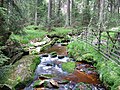 The Oder above the Oderteich
 -
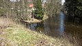 Confluence of the Sperrlutter
 -
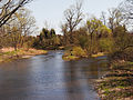
 The Oder in Bad Lauterberg
 -
 Confluence of Sieber (left) in the Oder (right) at Hattorf
 -
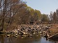 Oder-Wehr near Hattorf
 -
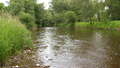 The Oder in Wulften


