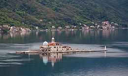
Our Lady of the Rocks
Native name: Gospa od Škrpjela | |
|---|---|
 | |
 | |
| Geography | |
| Location | Bay of Kotor |
| Area | 0.38 ha (0.94 acres) |
| Administration | |
Montenegro | |
Our Lady of the Rocks is one of the two
romanized
: Gospa od Škrpjela) is the largest building on the islet, and has a museum attached to it. There is also a small gift shop close to the church and a navigation light at the western end of the islet.
According to legend, the islet was made over the centuries by local seamen who kept an ancient oath after finding the icon of
Madonna and Child on the rock in the sea[2] on 22 July 1452.[3] Upon returning from each successful voyage, they laid a rock in the Bay. Over time, the islet gradually emerged from the sea.[4] The custom of throwing rocks into the sea is alive even nowadays. Every year on the sunset of 22 July, an event called fašinada in the local dialect, when local residents take their boats and throw rocks into the sea, widening the surface of the island, takes place.[2]
The church was renovated in 1722.embroidered by Jacinta Kunić-Mijović from Perast. It took her 25 years to finish it while waiting for her darling to return from a long journey, and eventually, she became blind. She used golden and silver fibres but what makes this tapestry so famous is the fact that she also embroidered her own hair in it.[3][5]
Gallery
See also
References
- ^ discover-montenegro.com: Gospa od Skrpjela Archived 2010-07-18 at the Wayback Machine
- ^ a b http://www.montenegro.com: Fašinada (by Nebojša Mandić)
- ^ a b http://www.montenegro.travel: Montenegro, Multicultural Heritage
- ^ a b c [1]: Gospa od Skrpjela (Our Lady of the Rocks), 25 April 1997
- ^ Adriatic Travel Club: Bay of Boka Kotorska
External links
 Media related to Gospa od Škrpjela at Wikimedia Commons


