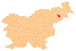
Pacinje
Pacinje | |
|---|---|
Styria | |
| Statistical region | Drava |
| Municipality | Ptuj |
| Area | |
| • Total | 2.62 km2 (1.01 sq mi) |
| Elevation | 218.9 m (718.2 ft) |
| Population (2022) | |
| • Total | 236 |
| [1] | |
Pacinje (pronounced Styria. It is now included with the rest of the municipality in the Drava Statistical Region.[2]
References
- ^ "Prebivalstvo po naseljih, podrobni podatki, 1. januar 2022". stat.si (in Slovenian). Retrieved 17 September 2022.
- ^ Ptuj municipal site
External links

