Palembang–Indralaya Toll Road
| Palembang–Indralaya Toll Road | |
|---|---|
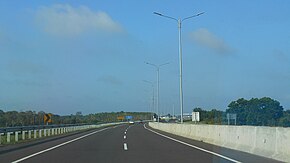
 Palembang–Indralaya Toll Road in 2020. | |
| Route information | |
| Maintained by PT Hutama Karya Tbk | |
| Length | 22 km (14 mi) |
| Existed | 2017–present |
| Major junctions | |
| Northeast end | Palembang |
| |
| Southwest end | Indralaya |
| Location | |
| Country | Indonesia |
| Provinces | South Sumatra |
| Major cities | Ogan Ilir Regency |
| Highway system | |
Palembang–Indralaya Toll Road (shortened to Palindra Toll Road) is a toll road in South Sumatra Province, Indonesia. This toll road is part of Trans-Sumatra Toll Road network.
History
Section I of this toll road (Palembang-Pemulutan) was inaugurated by President Joko Widodo on 12 October 2017.[1]
The Minister of Public Works and Housing, Basuki Hadimuljono, said that the construction of the toll road will be integrated with the development of the Merak-Bakauheni port. The road from the port will be connected with Palembang to the Tanjung Api-Api (TAA) port as part of President Joko Widodo's Sea Toll Program.[2]
The construction of Palindra Toll Road is dominated by swampy lands with heavy terrain which requires a special construction technique using Vacuum Consolidation Method (VCM). The planned lane on this toll road is 100 kilometres per hour (62 mph) with 2x2 lanes in the early stages and 2x3 in the final stages.[3]
The toll road was free since its inauguration until the end of 2017.[4]
Sections
|
Section |
Segment |
Length |
|---|---|---|
| I | Palembang-Pemulutan | 7 kilometres (4.3 mi) |
| II | Pemulutan-KTM Rambutan | 5 kilometres (3.1 mi) |
| III | KTM Rambutan-Indralaya | 10 kilometres (6.2 mi) |
Exits
| Province | Location | km | mi | Exit | Name | Destinations | Notes |
|---|---|---|---|---|---|---|---|
Jakabaring Sports City | Northeastern terminus | ||||||
| 1.0 | 0.62 | Palembang Toll Gate | |||||
| 1.9 | 1.2 | 2 | Pemulutan Interchange |
| Unbuilt as of 2022 | ||
| 6.8 | 4.2 | 7 | Pemulutan Toll Gate |
| |||
| West Pemulutan, Ogan Ilir Regency | 11.8 | 7.3 | 12 | KTM Rambutan Toll Gate |
| ||
| Indralaya, Ogan Ilir Regency | 20.0 | 12.4 | Indralaya Toll Gate | ||||
| 22.0 | 13.7 | 22 | Indralaya Ramp | Southwestern terminus | |||
1.000 mi = 1.609 km; 1.000 km = 0.621 mi
| |||||||
See also
References
- ^ "Peresmian Jalan Tol Palembang – Simpang Indralaya Seksi I: Palembang – Pemulutan" [Inauguration of the Palembang – Indralaya, Section I: Palembang – Pemulutan]. bpjt.pu.go.id (in Indonesian). Kementerian Pekerjaan Umum dan Perumahan Rakyat - Badan Pengawas Jalan Tol. 13 October 2017. Retrieved 2 August 2022.
- ^ "April Tol Palembang-Betung-Indralaya Dibangun, Pembebasan Lahan Dikebut" [April Palembang-Betung-Indralaya Toll Road Built, Land Acquisition Accelerated]. bappeda.sumselprov.go.id (in Indonesian). Badan Pembangunan Daerah Provinsi Sumatra Selatan. Retrieved 2 August 2022.
- ^ "Progres Pembangunan Jalan Tol Palembang – Indralaya Sudah Mencapai 97,47%" [Palembang – Indralaya Toll Road Construction Progress Has Reached 97.47%]. bpjt.pu.go.id (in Indonesian). Kementerian Pekerjaan Umum dan Perumahan Rakyat - Badan Pengawas Jalan Tol. 26 September 2018. Retrieved 2 August 2022.
- ^ Aries, Maspril (13 October 2017). Raharjo, Budi (ed.). "Tol Palembang Indralaya Diresmikan, Gratis Sampai Akhir Tahun" [Palembang-Indralaya Toll Road Inaugurated, Free Until the End of the Year]. republika.co.id (in Indonesian). Republika. Retrieved 2 August 2022.
