
Pea Ridge, Arkansas
Pea Ridge, Arkansas | ||
|---|---|---|
FIPS code 05-54200 | | |
| GNIS feature ID | 2404492[2] | |
| Website | cityofpearidge | |
Pea Ridge is a city in
The rural town is best known as the location of the pivotal American Civil War engagement the Battle of Pea Ridge, or, as it is locally known, the Battle of Elkhorn Tavern, which took place approximately 5 miles (8 km) east of the town. The site of the battle is preserved as the Pea Ridge National Military Park.
The town's downtown business district is on the National Register of Historic Places and largely comprises commercial structures from the late 19th and early 20th centuries. The population of Pea Ridge was 6,559 as of the 2020 census.[3] It is part of the Northwest Arkansas region. The local weekly newspaper is the Times of Northeast Benton County.
Geography
Arkansas Highway 94 is the main road through the city, leading south 8 miles (13 km) to the center of Rogers and northwest 6 miles (10 km) to the Missouri border. Arkansas Highway 72 leads east 5 miles (8 km) to U.S. Route 62 at Pea Ridge National Military Park, and southwest 9 miles (14 km) to Bentonville.
According to the United States Census Bureau, the city has a total area of 7.4 square miles (19.1 km2), all land.[3]
Demographics
| Census | Pop. | Note | %± |
|---|---|---|---|
| 1940 | 72 | — | |
| 1950 | 268 | 272.2% | |
| 1960 | 380 | 41.8% | |
| 1970 | 1,088 | 186.3% | |
| 1980 | 1,488 | 36.8% | |
| 1990 | 1,620 | 8.9% | |
| 2000 | 2,346 | 44.8% | |
| 2010 | 4,794 | 104.3% | |
| 2020 | 6,559 | 36.8% | |
| U.S. Decennial Census[4] | |||
2020 census
| Race | Number | Percentage |
|---|---|---|
White (non-Hispanic)
|
5,444 | 83.0% |
Black or African American (non-Hispanic)
|
55 | 0.84% |
Native American
|
59 | 0.9% |
Asian
|
39 | 0.59% |
Pacific Islander
|
4 | 0.06% |
Other/Mixed
|
437 | 6.66% |
Latino
|
521 | 7.94% |
As of the 2020 United States census, there were 6,559 people, 2,021 households, and 1,455 families residing in the city.
2010 census
As of the 2010 Census, Pea Ridge had a population of 4,794. The racial and ethnic composition of the population was 90.7% white, 0.7% African American, 0.9% Native American, 0.3% Asian, 2.0% from two or more races and 5.8% Hispanic or Latino.[6]
There were 1300 households, out of which 37.3% had children under the age of 18 living with them, 63.3% were married couples living together, 7.8% had a female householder with no husband present, and 24.1% were non-families. 21.6% of all households were made up of individuals, and 12.0% had someone living alone who was 65 years of age or older. The average household size was 2.63 and the average family size was 3.05.
In the city, the population was spread out, with 26.9% under the age of 18, 6.9% from 18 to 24, 29.5% from 25 to 44, 21.6% from 45 to 64, and 15.1% who were 65 years of age or older. The median age was 36 years. For every 100 females, there were 95.7 males. For every 100 females age 18 and over, there were 93.5 males.
The median income for a household in the city was $37,244, and the median income for a family was $42,222. Males had a median income of $29,340 versus $21,298 for females. The
Education
Most of Pea Ridge is zoned to the Pea Ridge School District. A small section is zoned to Rogers Public Schools.[7] Pea Ridge High School is the comprehensive high school of the former.
Image gallery
-
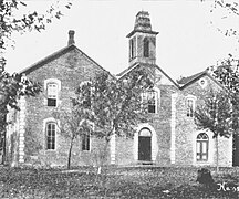 The 1880 Pea Ridge Masonic College building as it appeared in 1920, about ten years before it was razed
 -
 Downtown Pea Ridge looking east on Pickens Road in 1914. The white structure at the end of the street was a hotel operated by the Martin family, which burned down around 1920.
 -
 The original J.J. Putnam's general merchandise store, which later burned down and was replaced with a cement block building, which still stands on the southeast corner of Pickens Road and Curtis Avenue. This photo antedates 1914.
 -
 The cement block building that replaced J.J. Putnam's first general merchandise store, which burned, on the southeast corner of Pickens Road and Curtis Avenue in 1914.


See also
References
- ^ "2020 U.S. Gazetteer Files". United States Census Bureau. Retrieved October 29, 2021.
- ^ a b U.S. Geological Survey Geographic Names Information System: Pea Ridge, Arkansas
- ^ a b "Geographic Identifiers: 2010 Demographic Profile Data (G001): Pea Ridge city, Arkansas". U.S. Census Bureau, American Factfinder. Archived from the original on February 12, 2020. Retrieved September 23, 2013.
- ^ "Census of Population and Housing". Census.gov. Retrieved June 4, 2015.
- ^ "Explore Census Data". data.census.gov. Retrieved January 1, 2022.
- ^ 2010 general profile of population and housing characteristics of Pea Ridge from the US census
- U.S. Census Bureau. Retrieved May 25, 2022.
External links
- City of Pea Ridge official website
- Encyclopedia of Arkansas History & Culture entry: Pea Ridge (Benton County)
Municipalities and communities of Benton County, Arkansas, United States | ||
|---|---|---|
| Cities |  | |
| Towns | ||
| Townships | ||
| CDPs | ||
| Other communities | ||
| Ghost towns | ||
| Footnotes | ‡This populated place also has portions in an adjacent county or counties Bethel Heights, a former municipality, is now a part of Springdale | |
| ||