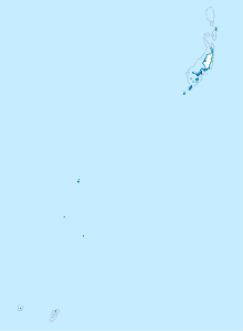
Peleliu Airfield
Peleliu Airfield | |||||||||||
|---|---|---|---|---|---|---|---|---|---|---|---|
AMSL 9 ft / 3 m | | ||||||||||
| Coordinates | 06°59′54″N 134°13′58″E / 6.99833°N 134.23278°E | ||||||||||
| Map | |||||||||||
| Runways | |||||||||||
| |||||||||||
Peleliu Airfield (
.History
Peleliu Airfield was built by the Japanese in 1944 with a pair of intersecting runways. During the
Having quickly captured the airfield,
After liberation, the Seabees further repaired, expanded and upgraded the airfield. The airbase was under the command of Colonel Karl S. Day. In December 1944, the two runways measured 6,000 by 300 feet (1,829 m × 91 m) and 3,900 by 260 feet (1,189 m × 79 m). A PBY that took off from Peleliu on 3 August 1945 was the first to locate survivors of the USS Indianapolis 4 days after it was sunk.
The USAAF
After the end of the war, Peleliu and its airfield were abandoned by the Americans. Today the vegetation on the island, which was largely burnt out by the battle, has regrown and has replaced the scars of war. As it had been heavily defended by the Japanese, there are still tanks,

Facilities and aircraft
The airport resides at an estimated
Airlines and destinations
Passenger
| Airlines | Destinations |
|---|---|
| Belau Air | Angaur, Koror |
| Pacific Mission Aviation | Koror |
See also
- USAAF in the Central Pacific
- Peleliu Naval Base
References
- ^ PDF, effective 2 July 2009.
- ^
 This article incorporates public domain material from the Air Force Historical Research Agency
- Maurer, Maurer (1983). Air Force Combat Units Of World War II. Maxwell AFB, Alabama: Office of Air Force History. ISBN 0-89201-092-4.
- Maurer, Maurer (1983). Air Force Combat Units Of World War II. Maxwell AFB, Alabama: Office of Air Force History.
External links


