Peter I Range
| Peter I Range Хребет Петра I | |
|---|---|
| Highest point | |
| Peak | Moscow Peak |
| Elevation | 6,785 m (22,260 ft) |
| Coordinates | 39°0′N 71°30′E / 39.000°N 71.500°E |
| Dimensions | |
| Length | 200 km (120 mi) E/W |
| Width | 40 km (25 mi) N/S |
| Geography | |
| Country | Tajikistan |
| Parent range | Pamir Mountains |
| Geology | |
| Age of rock | Mesozoic/Cenozoic |
| Type of rock | Sandstone and conglomerate |
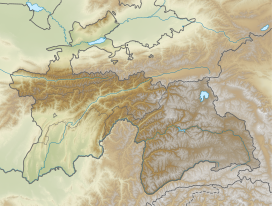
Peter I Range, Peter the First Range[1] or Peter the Great Range (Russian: Хребет Петра I or Хребет Петра Первого) is a mountain range in Tajikistan, part of the Pamir Mountain System. The range takes its name from Peter the Great (1672 – 1725).
Geography
Peter I Range is located in the south-east of
Region of Republican Subordination. It forms a westerly extension of the northern Pamirs, separating the watersheds of the Surchob in the north and the Obikhingou river in the south. The range stretches in a roughly east–west direction for about 200 km, connecting with the Academy of Sciences Range at its eastern end.[2]
Peaks
Its highest summit is
ultra-prominent Agasis Peak (5,877 m).[3]
See also
- List of mountains in Tajikistan
References
- ^ Hamburger et al. Peter I range, GSA Bull., 1992
- ^ Peter I Range - article from the Great Soviet Encyclopedia
- ^ Yevgeniy Gippenreiter, Vladimir Shataev. "Six and Seventhousanders of the Tien Shan and the Pamirs" (PDF 4,6 MB). Alpine Journal, 1996, 122–130.

