
Pharoah, Oklahoma
Pharoah | |
|---|---|
UTC-5 (CDT) | |
| GNIS feature ID | 1096590[1] |
Pharoah is an
US Route 75.[3] The community was named after a rancher and cattleman, O.J. Pharoah.[2][4] Oil and gas production have historically been important industries in Okfuskee County, and, in the 1920s, oil wells were drilled around Pharoah.[5] A post office opened in Pharoah on June 8, 1921;[5] the current nearest post office is in Weleetka.[6]
References
- ^ a b c 1096590
- ^ ISBN 9780806120287.
- ^ "Pharoah, OK". Google Maps. Retrieved June 30, 2020.
- ^ "Oklahoma's Strangely Named Towns—Pharoah, OK". Gary Horcher, The Oklahoman, August 19, 2000. Retrieved June 30, 2020.
- ^ a b Wilson, Linda D. "Okfuskee County," Encyclopedia of Oklahoma History and Culture. Oklahoma Historical Society. Accessed October 7, 2016.
- ^ "Find USPS Locations (using Pharoah, Oklahoma as the search term)". U.S. Postal Service. Retrieved June 3, 2021.
Municipalities and communities of Okfuskee County, Oklahoma, United States | ||
|---|---|---|
| City | 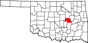 | |
| Towns | ||
| CDP | ||
| Other communities | ||
| Indian reservation | ||
| Footnotes | ‡This populated place also has portions in an adjacent county or counties | |
| ||
This Oklahoma state location article is a stub. You can help Wikipedia by expanding it. |