Pierreclos
Pierreclos | |
|---|---|
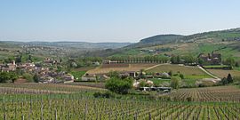
 A general view of Pierreclos | |
| Coordinates: 46°20′04″N 4°41′18″E / 46.3344°N 4.6883°E | |
| Country | France |
| Region | Bourgogne-Franche-Comté |
| Department | Saône-et-Loire |
| Arrondissement | Mâcon |
| Canton | La Chapelle-de-Guinchay |
| Area 1 | 12.41 km2 (4.79 sq mi) |
| Population (2021)[1] | 851 |
| • Density | 69/km2 (180/sq mi) |
| Time zone | UTC+01:00 (CET) |
| • Summer (DST) | UTC+02:00 (CEST) |
| INSEE/Postal code | 71350 /71960 |
| Elevation | 245–746 m (804–2,448 ft) (avg. 289 m or 948 ft) |
| 1 French Land Register data, which excludes lakes, ponds, glaciers > 1 km2 (0.386 sq mi or 247 acres) and river estuaries. | |
Pierreclos (French pronunciation: [pjɛʁklo]) is a commune in the Saône-et-Loire department in the region of Bourgogne-Franche-Comté in eastern France.
Geography
Situated 14 kilometers west of Mâcon and 14 kilometers south of Cluny, Pierreclos is a small vineyard village in the Tramayes county.
History
The name Pierreclos come from "Petra Clausa" meaning Closed stone, or tomb, in Latin. It was a necropolis for important people of the Roman Province.
Before the French Revolution, the history of the village was closely linked to its castle.

Demography
In 2016, the population of the village was 910 inhabitants.
Economy
Pierreclos is surrounded by vineyards which are used for great quality wines. The main employer is a low-cost salted meat producer.
Important People
Alphonse De Lamartine
had a child with Jacqueline de Pierreclos (Laurence in Jocelyn)
See also
References
- ^ "Populations légales 2021". The National Institute of Statistics and Economic Studies. 28 December 2023.
Wikimedia Commons has media related to Pierreclos.


