
Pieter Both (mountain)
| Pieter Both | |
|---|---|
| Peter Botte Mountain | |
Country high point | |
| Coordinates | 20°11′32″S 57°33′19″E / 20.1923°S 57.5552°E |
| Geography | |
 Pieter Both Location of Pieter Both in Mauritius | |
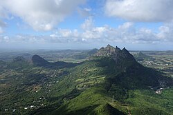
| Location | Mauritius, East Africa |
| Climbing | |
| First ascent | 7 September 1832 by |
Pieter Both, sometimes referred to as Peter Botte Mountain,
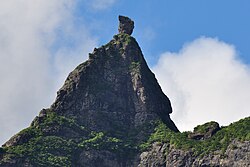
The notable feature of this mountain is the gigantic rock formation at the very top of it, which resembles a human head. The palm species Hyophorbe amaricaulis, famous for being the world's rarest palm today, was once a common sight on this mountain.[4]
The first ascent of Pieter Both was by Captain Lloyd, Lieutenant Phillpotts, of the 29th Reg., Lieutenant Keppel, R.N., and Lieutenant Taylor on 7 September 1832.[5]
To climb the mountain following the main ridge takes about an hour, and is mildly difficult. It is mainly a scramble, and being exposed, a rope is advised. The dramatic boulder on the pinnacle is about nine metres in diameter, and has several iron spikes fixed to it to aid climbing to the top. The top is flat and about two metres across.[6]
Gallery
-
 Mauritius Port Louis Vallée des Prêtres
 -
 Mountains - panoramio - pyraniton
 -
 Pieter Both
 -
 View from Le Pouce facing Pieter Both


.jpg)

References
- W. & R. Chambers Publishers. p. 465.
- ISBN 978-1-291-49267-5.
- ISBN 978-3-11-075991-4.
- ISSN 1365-3008.
- JSTOR 1797600.

- ^ Jahp, Alex (24 July 2016). "Pieter Both". Explore Mauritius.
Further reading
- Macmillan, Allister (1914). Mauritius: Illustrated. Historical and Descriptive, Commercial and Industrial Facts, Figures, and Resources. W.H. & L. Collingridge.
This Mauritius location article is a stub. You can help Wikipedia by expanding it. |