
Plaza de Cibeles
Ayuntamiento of Madrid | |
| Location | Madrid, Spain |
|---|---|
| Coordinates | 40°25′10″N 3°41′35″W / 40.419335°N 3.693088°W |
The Plaza de Cibeles is a square with a neo-classical complex of marble sculptures with fountains that has become a symbol for the city of Madrid. It sits at the intersection of Calle de Alcalá (running from east to west), Paseo de Recoletos (to the North) and Paseo del Prado (to the south). Plaza de Cibeles was originally named Plaza de Madrid, but in 1900, the City Council named it Plaza de Castelar, which was eventually replaced by its current name.
It is currently delimited by four prominent buildings: the
.Over the years, Cybele Palace and her fountain have become symbolic monuments of the city.[1][2][3]
Cibeles Fountain
The fountain of Cybele is found in the part of Madrid commonly called the
Cybele Palace
The most prominent of the buildings at the Plaza de Cibeles is the Cybele Palace (formerly named
Gallery
-
 Statue of Cybele by Francisco Gutiérrez Arribas
 -
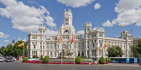 Cybele Palace (formerly Palace of Communications)
 -
 Night view of the Plaza, with the
Metropolis Building -
 View from the Calle de Alcalá


_12.jpg)
_02.jpg)
References
- ^ "Plaza de Cibeles | Spain.info in English". Spain.info. Retrieved 2012-06-13.
- ^ "Madrid's Palacio de Cibeles Renovated Into Jaw-Dropping CentroCentro Cultural Center | Inhabitat - Sustainable Design Innovation, Eco Architecture, Green Building". Inhabitat. 31 May 2011. Retrieved 2012-06-13.
- ^ "Cibeles Fountain - Tourism in Madrid". Turismomadrid.es. Archived from the original on 2012-12-18. Retrieved 2012-06-13.
- ^ The players and thousands of fans celebrated the Champions League won together