Port Alfred Airport
Port Alfred Airport | |||||||||||
|---|---|---|---|---|---|---|---|---|---|---|---|
| |||||||||||
| Coordinates | 33°33′15″S 26°52′47″E / 33.55417°S 26.87972°E | ||||||||||
| Map | |||||||||||
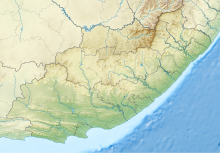
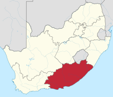
Location of airport in Eastern Cape province | |||||||||||
| Runways | |||||||||||
| |||||||||||
Source:[1] | |||||||||||
Port Alfred Airport (IATA: AFD[2], ICAO: FAPA) is an airport in the seaside town of Port Alfred, located in the Eastern Cape province on the southern coast of South Africa.
Facilities
The airport resides at an
mean sea level. It has three runways, the longest of which is 1,828 metres (5,997 ft).[1]
References
- ^ a b "Airport information for Port Alfred, South Africa (FAPA / AFD)". Great Circle Mapper. Retrieved 17 June 2013.
- ^ "IATA Airport Code Search (AFD: Port Alfred)". International Air Transport Association. Retrieved 17 June 2013.
External links
- Aeronautical chart and airport information for FAPA at SkyVector
- Accident history for AFD at Aviation Safety Network


