
Portal:Surrey/Selected pictures
-
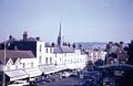 A 1959 view of South Street in Dorking, Surrey.
 -
 Nemesis Inferno at Thorpe Park in the north-west of the county
 -
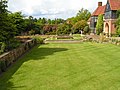 Lawns atRHS Garden, Wisley, north-east of Guildford
 -
-

-
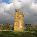 Leith Hill Tower, peak of the Greensand Ridge
 -

-
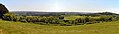 View of the Vale of Holmesdale and Winterfold Forest from Newlands Corner, near Clandon and Albury, east of Guildford
 -
 Autumn at Denbies Vineyard looking across the Mole Gap to Box Hill, the steepest slopes of the North Downs
 -
 The town of Dorking and its section of the Vale of Holmesdale from Box Hill in the North Downs, with more heavily wooded Greensand Hills beyond. These sets of hills make up the Surrey Hills AONB.
 -
 The lower end of the Staines-upon-Thames reach of the Thames, showing typical trees of the next reach and Penton Hook Island, a small nature reserve.
 -
 Walton Bridge built in the 2010s is a landmark of the northerly Spelthorne and Elmbridge boroughs
 -
 Devil's Punch Bowl is the National Trust extinct caldera in the south-west of the south-western Borough, Waverley
 -
 Remains of the undercroft of the lay brothers' refectory at Waverley Abbey, near Farnham, main town of the Borough of Waverley
 -
 Typical interior of old pub-restaurant, semi-rural example near Reigate in the east of the county
 -
 Waterfall at Virginia Water on the north-western (Berkshire) border
 -
 One of the several golf courses in Woking's borough in the mid/north-west of the county
 -
 McLaren Technology Centre, Woking
 -
 Great Fosters restaurant/hotel, Runnymede
 -
 Pineferous forest of the sandy Bagshot Formation spanning parts of four boroughs towards the north-west and in the far west of the county, with defensive positions for historic army training near Deepcut and Pirbright
 -
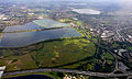 Seven reservoirs. View of four in Spelthorne with small lakes of lower elevation, from aggregate extraction, in the south of the borough to the right. Beyond three reservoirs in Elmbridge. The flattest areas of the far north of the county. Staines road and rail bridges span the Thames into Runnymede in the right of the photograph.
 -
 Epsom Downs, a racecourse which hosts The Derby annually. One of four in the county.
 -
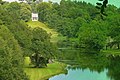 Painshill Park in Cobham has follies on natural, but landscaped slopes by part of the Mole disguised as ornamental lakes and the Great Cedar thought to be the largest Cedar of Lebanon in Europe. In the mid-north of the county.
 -
 Georgian hotel/restaurant typical of many larger Surrey villages and its oldest towns.


.jpg)


