
Promise Island
Region Kivalliq | | |
| Demographics | ||
|---|---|---|
| Population | Uninhabited | |
Promise Island (Inuktitut: Nannuyuma; meaning: "polar bear")[1] is located near the western shore of Hudson Bay.[2] It is barely a square kilometre in area and rises 300 ft (91 m) in elevation on its northern side.[3] It is located about 9 km (5.6 mi)[4] from the community of Chesterfield Inlet, Nunavut, Canada, and is part of a loose chain of small islands running along the coast, including the Wag Islands and Pitsiulartok (Fairway Island).
The island is home to a wide range of wildlife, including the
harbour seal (phoca hispida), the polar bear, the brown lemming (lemmus t. trimucronatus), the barren-ground caribou (rangifer arcticus), and the red phalarope.[5][6]
-
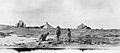 "Natives, Promise Island" Photo c. 1920-25 by Hudson's Bay Company employee Capt. George Cleveland of the motor schooner Fort Chesterfield.

References
- ^ Arctic Institute of North America. "Field Notes on Mammals of the Chesterfield Inlet District of Keewatin" (PDF). ucalgary.ca. Retrieved 2008-04-15.
- ^ "Promise Island, Nunavut, Canada". travelingluck.com. Retrieved 2008-04-15.
- ^ Geological Survey of Canada (1898). Annual Report. The Survey. p. 80. Retrieved 2008-04-16 – via Internet Archive.
Promise Island.
- ^ "Geographic features & Photographs around Chesterfield Inlet, in Nunavut, Canada". travelingluck.com. Retrieved 2008-04-15.
- ^ Arctic Institute of North America. "Field Notes on Mammals of the Chesterfield Inlet District of Keewatin" (PDF). ucalgary.ca. Retrieved 2008-04-16.
- ^ Arctic Institute of North America. "Observations on the Breeding Behaviour of Phalaropes" (PDF). ucalgary.ca. Retrieved 2008-04-16.
This Kivalliq Region, Nunavut location article is a stub. You can help Wikipedia by expanding it. |