Foxe Basin
| Foxe Basin | |
|---|---|
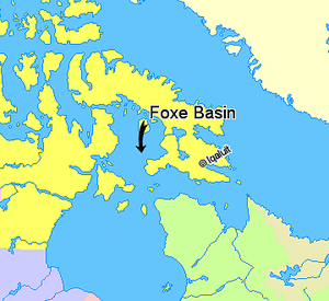
 Map indicating Foxe Basin | |
| Location | South of Baffin Island, Nunavut |
| Coordinates | 65°55′50″N 77°55′10″W / 65.93056°N 77.91944°W[1] |
| Type | Bay |


Foxe Basin is a shallow
The nutrient-rich cold waters found in the basin are known to be especially favourable to
The basin takes its name from the English explorer Luke Foxe who entered the lower part in 1631.[3]
Waterway
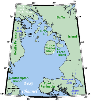
Foxe Basin is a broad, predominantly shallow depression, generally less than 100 metres (330 ft) in depth, while to the south, depths of up to 400 metres (1,300 ft) occur.
Foxe Basin is connected to the
Coast
The terrain is rocky and rugged in the southern half of the region, and generally low-lying in the north. High cliffs are found across the southern portion of the region, where most of the seabirds nest. Coastal marshes and tidal flats up to 6.5 km (4 mi) in width are found in the vast lowland section of eastern Foxe Basin, as well as in the bays of Southampton Island.
Wildlife


This is one of the little-known areas of the Canadian Arctic, though it is proving to be biologically rich and diverse. The numerous polynyas in northern Foxe Basin support high densities of bearded seals and the largest walrus herd in Canada (over 6,000 individuals). Ringed seal and polar bear are common, with north Southampton Island as one of the highest-density polar bear denning areas in Canada.[4]
This area is also an important summering area for the bowhead whale,[5] beluga whale and narwhal. Both bowhead whales and belugas winter in the waters of northeastern Hudson Bay. Bowheads were the only known baleen whales to occur in the Hudson Bay, but recently some other species of whale, such as humpback and minke, are confirmed to migrate into the waters as well.[6]
The region is the main
Status
This region is not yet represented in the national marine conservation areas system. Studies to identify preliminary representative marine areas have yet to be undertaken.
References
- ^ "Foxe Basin". Geographical Names Data Base. Natural Resources Canada.
- ^ Finlayson, Douglas; Clarke, R. Allyn (15 December 2013). "Foxe Basin". The Canadian Encyclopedia. Historica Canada.
- ^ Foxe, Luke National Historic Person. Directory of Federal Heritage Designations. Parks Canada.
- ^ a b Paulic, J.E.; Cleator, H.; Martin, K.A. (August 2014). Ecologically and Biologically Significant Areas (EBSA) in Northern Foxe Basin, Nunavut: identification and delineation (PDF) (Report). Fisheries and Oceans Canada. Research Document 2014/042.
- ^ Hudson Bay-Foxe Basin Bowhead Whales (PDF) (Report). Fisheries and Oceans Canada. October 1999. Stock Status Report E2-52.
- S2CID 85843505.
Further reading
- Anders, G. Northern Foxe Basin An Area Economic Survey. Ottawa: Industrial Division, Northern Administration Branch, Dept. of Northern Affairs and National Resources, 1965.
- Campbell, N. J., and A. E. Collin. The Discolouration of Foxe Basin Ice. [S.l.]: Atlantic Oceanographic Group, 1957.
- Colby WB, and JF Cleall. 1974. "Cephalometric Analysis of the Craniofacial Region of the Northern Foxe Basin Eskimo". American Journal of Physical Anthropology. 40, no. 2: 159–70.
- Cosens, Susan E., and Andries Blouw. Age Classes of Bowhead Whales Summering in Northern Foxe Basin. Ottawa: Fisheries and Oceans, 1999.
- Crowe, Keith J. A Cultural Geography of Northern Foxe Basin, N.W.T. Ottawa: Northern Science Research Group, Dept. of Indian Affairs and Northern Development, 1969.
- Fisher, K I, and R E A Stewart. 1997. "Summer Foods of Atlantic Walrus, Odobenus Rosmarus Rosmarus, in Northern Foxe Basin, Northwest Territories". Canadian Journal of Zoology. 75, no. 7: 1166.
- Forgeron, F. D. A Preliminary Study of Foxe Basin Bottom Sediments. [S.l.]: Atlantic Oceanographic Group, 1959.
- Gaston, Anthony J., Stephen A. Smith, Robert Saunders, G. Ilya Storm, and Jane A. Whitney. 2007. "Birds and Marine Mammals in Southwestern Foxe Basin, Nunavut, Canada". Polar Record. 43, no. 1: 33–47.
- Geological Survey of Canada. Northern Foxe Basin. Open file (Geological Survey of Canada), 2382. 1992.
- Greisman, Paul. Tidal Propagation Measurements in Foxe Basin. Canadian contractor report of hydrography and ocean sciences, no. 18. [Ottawa?]: Atlantic Region, Canadian Hydrographic Service, Ocean Science and Surveys, Atlantic, 1984.
- Manning, T. H. The Foxe Basin Coasts of Baffin Island. Geographical Journal, Vol.101,No.5-6. 1943.
- Northwest Territories. Foxe Basin Polar Bear Research Program ... Field Report. [Yellowknife?]: Northwest Territories Resources, Wildlife & Economic Development, 1984.
