
Quiraing

The Quiraing (
Scottish Gaelic: Cuith-Raing)[1] is a landform on the eastern face of Meall na Suiramach, the northernmost summit of the Trotternish escarpment on the Isle of Skye, Scotland. It takes the form of a craterous hollow surrounded by a high rampart of rock.[2] Within the hollow is a raised plateau the size of a football field, known as the Table. Other distinctive features of the landscape are the Needle, a jagged pinnacle rising to 120 feet (37 m), and the Prison, a mass of rock resembling a medieval keep.[3][4]
Like the rest of the Trotternish escarpment, the Quiraing was formed when a thick layer of
sedimentary rocks below, causing a succession of landslides.[5] It has been renowned for its fantastical appearance since the Victorian period. The poet Alexander Smith dubbed it "a nightmare of nature".[6]
-
 View of the Quiraing (left) and the Prison (right)
 -
 The Prison
 -
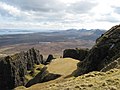
 The entrance to the Quiraing
 -
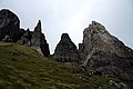
 The Needle
 -
 The Table


.JPG)


References
- ^ Henderson, George (1910). The Norse Influence on Celtic Scotland. Glasgow: James MacLehose. p. 61.
- ^ Groomes, Francis H. (n.d.). Ordnance Gazetteer of Scotland: A Survey of Scottish Topography, Statistical, Biographical, and Historical. Vol. 5 (2nd ed.). London: William Mackenzie. pp. 231–232.
- ISBN 978-0-00-220200-8.
- ISBN 978-1-4262-0671-9.
- .
- ^ Smith, Alexander (1866). A Summer in Skye. London and New York: Alexander Strahan. p. 232.
External links
 Media related to Quiraing at Wikimedia Commons