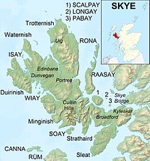
Minginish

Minginish (
Much of the interior is uninhabited and the terrain is a series of hills and mountains dissected by steep-sided valleys such as Glen Brittle and Glen Eynort. To the east, Loch Coruisk, which has been painted by William Daniell and J. M. W. Turner amongst others and visited by Walter Scott.[2] is only accessible by boat or on foot via a track from Sligachan. It is also possible to walk from Elgol, but one section of the path ("the Bad Step") presents some potential difficulties for the nervous or inexperienced.
There are a number of small settlements in Minginish, principally along the south & east coast of Loch Harport & the north west coast of Loch Bracadale (from which Loch Harport originates), including
whisky is distilled in Carbost.The A87 (which runs south to north up Skye from Kyleakin up to Uig) touches Minginish at Sligachan.
The Gaelic name Minginis means "main headland" with the old Norse name being "Mikil Nes" meaning great headland.[3]
Notable residents
- Roderick John MacLeod, Lord Minginish (born c. 1953), Chairman of the Scottish Land Court since 2014, was raised in Portnalong in Minginish and now lives in Edinburgh.[4]
See also
Footnotes
- ^ "Minginis". Gazetteer for Scotland. Retrieved 25 November 2009.
- ISBN 978-1-84195-454-7.
- ^ Iain Mac an Tàilleir. "Placenames" (PDF). Pàrlamaid na h-Alba. Archived from the original (PDF) on 26 September 2011. Retrieved 23 July 2007.
- ^ "New Land Court Chairman installed". Judiciary of Scotland website. 17 October 2014. Retrieved 27 December 2015.
57°15′N 6°19′W / 57.25°N 6.31°W
