
Ramsgate Beach, New South Wales
| Ramsgate Beach Federal division(s) | Cook | ||||||||||||||
|---|---|---|---|---|---|---|---|---|---|---|---|---|---|---|---|
| |||||||||||||||
Ramsgate Beach is a
History
The area between the Cooks River and Georges River was originally known as Seven Mile Beach. It was changed to Lady Robinson's Beach in 1874 to honour Governor Sir Hercules Robinson's wife. Cook Park is named after Samuel Cook who advocated it as a public pleasure area. Ramsgate was named after the seaside resort in England. A model village was originally planned for the suburb but later abandoned.[2]
Geography
Ramsgate Beach is surrounded by the suburbs of
Population
According to the 2016 census of Population, there were 1,660 people usually resident in Ramsgate Beach. 58.4% of people were born in Australia. 52.0% of people spoke only English at home. Other languages spoken at home included Greek at 12.6%. The most common responses for religious affiliation were Catholic 23.6%, Eastern Orthodox 18.5% and Anglican 12.8%.[1]
Landmarks
- Lady Robinsons Beach
- Cook Park
- Ramsgate Beach Baths
- Ramsgate Baptist Church
-
 Ramsgate Beach Plaza, Ramsgate Road
 -
 Restaurant, Cook Park
 -
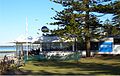
 Life Saving Club, Cook Park
 -
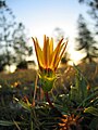 Ramsgate Beach Flower
 -
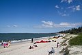 Lady Robinsons Beach


.jpg)
References
- ^ a b Australian Bureau of Statistics (27 June 2017). "Ramsgate Beach (State suburb)". 2016 Census QuickStats. Retrieved 11 April 2018.
- ISBN 0-207-14495-8, pages 216-217