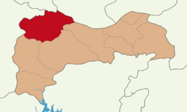
Refahiye District
Appearance
Refahiye District | |
|---|---|
 Map showing Refahiye District in Erzincan Province | |
| Coordinates: 39°54′N 38°46′E / 39.900°N 38.767°E | |
| Country | Turkey |
| Province | Erzincan |
| Seat | Refahiye |
| Government | |
| • Kaymakam | Ömer Faruk Canpolat |
| Area | 1,808 km2 (698 sq mi) |
| Population (2022) | 11,269 |
| • Density | 6.2/km2 (16/sq mi) |
| Time zone | UTC+3 (TRT) |
| Website | www |
Refahiye District is a district of the Erzincan Province of Turkey. Its seat is the town of Refahiye.[1] Its area is 1,808 km2,[2] and its population is 11,269 (2022).[3]
Composition
The district is predominantly populated by Sunni Turks and Alevi Kurds.[4][5] There are moreover a Georgian presence among the Sunni Turkish-populated villages and few Alevi Turkish villages as well.[6]
Some of the settlements were formerly populated by either Armenians or Greeks.[7]
Settlements
There is one municipality in Refahiye District:[1]
There are 121 villages in Refahiye District:[8]
- Ağmusa
- Akarsu
- Akbağ
- Akçiğdem
- Alacatlı
- Alaçayır
- Alapınar
- Altköy
- Ardıçlık
- Armutlu
- Arpayazı
- Aşağısütlü
- Aslanyusuf
- Aşut
- Avşarözü
- Aydıncık
- Aydoğan
- Babaaslan
- Bakacak
- Baloğlu
- Baştosun
- Biçer
- Bölüktepe
- Bostandere
- Çaltı
- Çamdibi
- Çamlımülk
- Çatak
- Çatalçam
- Çatköy
- Çavuşköy
- Cengerli
- Çiçekali
- Çıragediği
- Çukurçimen
- Çukuryazı
- Damlaca
- Derebaşı
- Diştaş
- Diyarlar
- Doğandere
- Dolaylı
- Ekecik
- Erecek
- Gazipınarı
- Gemecik
- Göçevi
- Gökseki
- Gölköy
- Gülensu
- Gümüşakar
- Günyüzü
- Güventepe
- Güzle
- Hacıköy
- Halitler
- Kabuller
- Kaçakköy
- Kadıköy
- Kalkancı
- Kamberağa
- Kandilköy
- Kanlıtaş
- Karasu
- Karayaprak
- Kayıköy
- Kazören
- Keçegöz
- Kersen
- Kırantepe
- Kırıktaş
- Kırkbulak
- Kızıleniş
- Koçkaya
- Konakköy
- Kürelik
- Kuzuluk
- Laleli
- Leventler
- Madendere
- Mendemebaşı
- Mendemeçukuru
- Merkez Kalkancı
- Muratçayırı
- Mülkköy
- Olgunlar
- Onurlu
- Ören
- Ortagöze
- Perçem
- Pınaryolu
- Resullar
- Sağlık
- Şahaloğlu
- Şahverdi
- Saipköy
- Salur
- Sarhan
- Sarıbayır
- Sarıkoç
- Sıralı
- Söğütlü
- Teknecik
- Tepeköy
- Topağaç
- Tülüköy
- Tuzluçayır
- Üçören
- Ulucak
- Uludere
- Yaylabeli
- Yaylapınar
- Yazıgediği
- Yazıköy
- Yeniköy
- Yeniyurt
- Yıldızören
- Yukarısütlü
- Yukarıyeniköy
- Yurtbaşı
- Yuvadağı
References
- ^ a b İlçe Belediyesi, Turkey Civil Administration Departments Inventory. Retrieved 1 March 2023.
- ^ "İl ve İlçe Yüz ölçümleri". General Directorate of Mapping. Retrieved 1 March 2023.
- TÜİK. Retrieved 13 March 2023.
- ISBN 9789754780888.
- ISBN 9783882264180.
- ^ Kaplanoğlu, Yücel (2009). Refahiye'nin sosyo-kültürel ve dini yapısı üzerine bir inceleme (Thesis) (in Turkish). p. 37.
- ^ Kaplanoğlu, Yücel (2009). Refahiye'nin sosyo-kültürel ve dini yapısı üzerine bir inceleme (Thesis) (in Turkish). p. 5 and 115.
- ^ Köy, Turkey Civil Administration Departments Inventory. Retrieved 1 March 2023.

