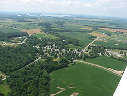
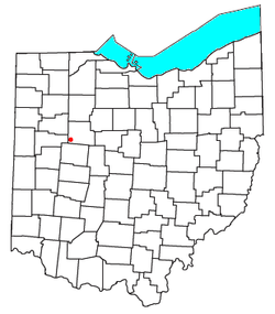
Roundhead, Ohio


Roundhead is an
History

The first Euro-American settlement at Roundhead was made in 1832 on the site of a former Wyandot Indian village.[2] The community is named for the Wyandot chief Roundhead.[3] During its history, the community has also been referred to as "Round Head", "Round Heads", "Round Headstown", and "Roundheads Town".[4] A post office has been in operation at Roundhead since 1837.[5]
An archaeological site, the Zimmerman Kame, is located in the Roundhead vicinity; it is listed on the National Register of Historic Places.[6]
Geography
Located at an altitude of 1,004 feet (306 m),
Community
Besides its post office, the community includes a Park, a volunteer fire department,[11] a United Methodist Church, a restaurant/bar, and two cemeteries.[12][13]
References
- ^ USPS – Cities by ZIP Code
- ^ Kohler, Minnie Ichler (1910). A Twentieth Century History of Hardin County, Ohio: A Narrative Account of Its Historical Progress, Its People and Principal Interests,. Lewis Publishing Company. p. 186.
- ^ The History of Hardin County, Ohio. Warner Beers & Company. 1883. p. 254.
- ^ a b U.S. Geological Survey Geographic Names Information System: Roundhead, Ohio
- ^ "Hardin County". Jim Forte Postal History. Retrieved December 14, 2015.
- ^ "National Register Information System". National Register of Historic Places. National Park Service. March 13, 2009.
- ISBN 0-89933-281-1.
- ^ "Find a County". National Association of Counties. Retrieved June 7, 2011.
- ISBN 0-89933-281-1.
- ISBN 0-89933-281-1.
- ^ U.S. Geological Survey Geographic Names Information System: Roundhead Volunteer Fire Department
- ^ U.S. Geological Survey Geographic Names Information System: Old Roundhead Cemetery
- ^ U.S. Geological Survey Geographic Names Information System: New Roundhead Cemetery
40°33′34″N 83°50′07″W / 40.55944°N 83.83528°W

