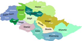
Roundu District
This article needs additional citations for verification. (April 2013) |
Rondu District
། | ||
|---|---|---|
Deputy Commissioner N/A | | |
| • District Police Officer | N/A | |
| • District Health Officer | N/A | |
| Area | ||
| • Total | 8,500 km2 (3,300 sq mi) | |
| Population | ||
| • | 109,000 | |
| Number of tehsils | 0 | |
Rondu District (
Rondu District was carved out of Skardu District in 2019.[4]

Demographics
The people of the Rondu Valley are predominantly
Shia sect of Islam. The district headquarters is the town of Thowar, which is about 65–70 km from Skardu. Although the population of Dambudas is less than that of the Stak, Thorchay, and Tormik valleys, Dambudas
is located in the middle of the Rondu Valley, so it currently serves as the district headquarters. The literacy rate of the district is approximately 90%. About 70% of the residents speak Balti, and around 30% speak Shina, but most Shina people are bilingual, due to having living with Balti people for a long time. The Rondu District has very scenic and lush green valleys, such as Bilamik, Talu Broq, Tormik, and Gunji, and has four union councils: Mindi, Stak, Tormik, and Gunji.
References
- ^ due weightin the coverage. Although "controlled" and "held" are also applied neutrally to the names of the disputants or to the regions administered by them, as evidenced in sources (h) through (i) below, "held" is also considered politicized usage, as is the term "occupied," (see (j) below).
(a) Kashmir, region Indian subcontinent, Encyclopaedia Britannica, retrieved 15 August 2019 (subscription required) Quote: "Kashmir, region of the northwestern Indian subcontinent ... has been the subject of dispute between India and Pakistan since the partition of the Indian subcontinent in 1947. The northern and western portions are administered by Pakistan and comprise three areas: Azad Kashmir, Gilgit, and Baltistan, the last two being part of a territory called the Northern Areas. Administered by India are the southern and southeastern portions, which constitute the state of Jammu and Kashmir but are slated to be split into two union territories.";
(b) Pletcher, Kenneth, Aksai Chin, Plateau Region, Asia, Encyclopaedia Britannica, retrieved 16 August 2019 (subscription required) Quote: "Aksai Chin, Chinese (Pinyin) Aksayqin, portion of the Kashmir region, at the northernmost extent of the Indian subcontinent in south-central Asia. It constitutes nearly all the territory of the Chinese-administered sector of Kashmir that is claimed by India to be part of the Ladakh area of Jammu and Kashmir state.";
(c) "Kashmir", Encyclopedia Americana, Scholastic Library Publishing, 2006, p. 328,ISBN 978-1-84904-621-3Quote:"Some politicised terms also are used to describe parts of J&K. These terms include the words 'occupied' and 'held'." - ^ Ali, Wazir Qalbi (2005). Qadam Qadam Baltistan. Skardu: Baltistan Book Depot.
- ^ Hussainabadi, Yousaf (2003).
Tareekh-e-Baltistan. Baltistan Book Depot, Skardu. Jabir, Abdul Hayee - ^ "GB cabinet decides to upgrade Dareal, Tangir,Gupis Yasin and Roundu as districts". Radio Pakistan. 20 April 2019. Retrieved 19 June 2019.

