Ryfylke
Ryfylke | |
|---|---|
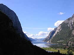
 View of the Lysefjorden | |
 Ryfylke | |
| Coordinates: 59°13′39″N 6°14′50″E / 59.2275°N 6.2472°E | |
| Country | Norway |
| County | Rogaland |
| Region | Vestlandet |
| Area | |
• Total | 4,546 km2 (1,755 sq mi) |
| Population (2015) | |
• Total | 33,511 |
| • Density | 7.4/km2 (19/sq mi) |
| Demonym | Ryfylkebu |
Ryfylke is a
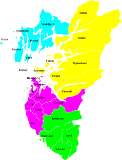
Ryfylke comprises the contemporary municipalities of Sauda, Suldal, Hjelmeland, Strand, Kvitsøy, the eastern island portion of Stavanger, the Forsand part of Sandnes, and eastern Gjesdal. There are no large cities in Ryfylke, but there are two large towns, Sauda and Jørpeland.
Scenic attractions include the Lysefjord with the mountains of Preikestolen ("Pulpit Rock") and Kjerag. The landscape of Ryfylke is characterized by high mountains in the interior; the highest and wildest are located in the north and are formed by hard, igneous rock.[1]
At Haukalivatnet Lake (near Lysefjorden), there is a distinct end moraine presumably created by a prehistoric glacier. This moraine led professor Jens Esmark (in 1824) to formulate the theory of an ice age over Scandinavia and other parts of the world. Esmark believed that climate change due to changes in Earth's orbit caused the ice ages.[2]
Etymology
The
References
- ^ Store norske leksikon. "Ryfylke"(in Norwegian). Retrieved 2016-02-10.
- ^ Hestmark, G. (2018). Jens Esmark's mountain glacier traverse 1823− the key to his discovery of Ice Ages. Boreas, 47(1), 1-10.
External links

