
Saint-Michel tumulus
You can help expand this article with text translated from the corresponding article in German. (October 2012) Click [show] for important translation instructions.
|
.jpg) | |
| Location | Carnac, France |
|---|---|
| Region | Brittany |
| Coordinates | 47°35′16″N 3°04′25″W / 47.5879°N 3.0735°W |
| Type | Tumulus |
| Length | 125 metres (410 ft) |
| Width | 60 metres (200 ft) |
| Height | 10 metres (33 ft) |
The Saint-Michel tumulus is a megalithic
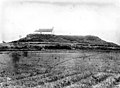
It is the largest grave mound in continental Europe.History

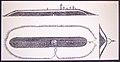
The tumulus was built during the fifth millennium BC. It consists of a mound of earth and stones 125 metres (410 ft) long, 50 metres (160 ft) wide and 10 metres (33 ft) high.[1] Explored in 1862, researchers found there a central vault containing fairly prestigious funerary furniture: axes, pearls, flint tools and sillimanite.
It has been classified as a "Monument historique" (National heritage site) since 1889.
Around 1900, the archaeologist Zacharie Le Rouzic again excavated the Saint-Michel tumulus and discovered a second dolmen and fifteen small stone chests, thus revealing the complexity of this monument.
Gallery
-
-
-
-

-

-

-
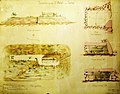
![Saint-Michel tumulus plan by Zacharie Le Rouzic [fr]](//upload.wikimedia.org/wikipedia/commons/thumb/c/c3/132_Plan_du_tumulus_Saint-Michel.JPG/120px-132_Plan_du_tumulus_Saint-Michel.JPG) Saint-Michel tumulus plan by Zacharie Le Rouzic
Saint-Michel tumulus plan by Zacharie Le Rouzic -
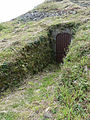 Excavation entrance to the tumulus
 -
 Finds from the Saint-Michel tumulus
 -
 Jade axes from the tumulus
 -
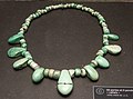 Callais necklace from the tumulus
 -
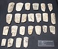 Broken stone axes from the tumulus


.jpeg)
![Saint-Michel tumulus plan by Zacharie Le Rouzic [fr]](/File:132_Plan_du_tumulus_Saint-Michel.JPG)
.jpg)


References
- ^ a b "Saint-Michel tumulus". www.megalithes-morbihan.com. Retrieved 6 November 2014.
| Authority control databases: Geographic |
|---|