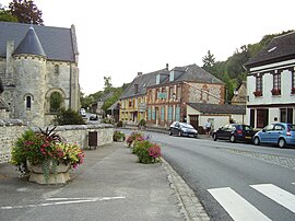
Saint-Wandrille-Rançon
Appearance
Saint-Wandrille-Rançon | |
|---|---|
Part of Rives-en-Seine | |
 | |
Notre-Dame-de-Gravenchon | |
| Commune | Rives-en-Seine |
| Area 1 | 18.11 km2 (6.99 sq mi) |
| Population (2019)[1] | 1,193 |
| • Density | 66/km2 (170/sq mi) |
| Time zone | UTC+01:00 (CET) |
| • Summer (DST) | UTC+02:00 (CEST) |
| Postal code | 76490 |
| Elevation | 2–122 m (6.6–400.3 ft) (avg. 16 m or 52 ft) |
| 1 French Land Register data, which excludes lakes, ponds, glaciers > 1 km2 (0.386 sq mi or 247 acres) and river estuaries. | |
Saint-Wandrille-Rançon (French pronunciation: [sɛ̃ vɑ̃dʁij ʁɑ̃sɔ̃]) is a former commune in the Seine-Maritime department in the Normandy region in north west France. On 1 January 2016, it was merged into the new commune of Rives-en-Seine.[2]
Geography
A village of
farming and forestry situated by the banks of the Seine, some 18 miles (29 km) north-west of Rouen at the junction of the D22, D33 and the D982 roads. Until 1960, the Pont de Brotonne
was the first bridging point of the Seine. Today it carries the D490 over the river.
Heraldry
 |
The arms of Saint-Wandrille-Rançon are blazoned: Vert, a pall wavy Argent between one mill wheel and two fleurs-de-lys Or.
|
Places of interest
It is celebrated for the ruins of its
Huguenots
, and again the restoration was not finished for more than a hundred years. The demolition of the church began at the time of the Revolution but stopped in 1832.
Population
| Year | 1962 | 1968 | 1975 | 1982 | 1990 | 1999 | 2006 |
|---|---|---|---|---|---|---|---|
| Population | 1061 | 1106 | 1261 | 1184 | 1151 | 1172 | 1196 |
| From the year 1962 on: No double counting—residents of multiple communes (e.g. students and military personnel) are counted only once. | |||||||
See also
References
External links
Wikimedia Commons has media related to Saint-Wandrille-Rançon.
- Website about the village of Saint-Wandrille-Rançon (in French)
- Website of the Abbey of Saint-Wandrille (in French)

