
Saint Petersburg City Duma

Ratusha, but his son, Alexander I, had the Duma restored four years later. The next emperor, Nicholas I, expanded the institution from six to twelve members in 1846. Alexander II of Russia reorganized it once again during the Zemstvo reform of the 1870s. In September 1918 the Duma was abolished and its functions devolved on the Petrograd Soviet.
The
Neo-Renaissance
style, favoured by Nicholas I. Two more floors were added to the building in 1913–14. A spacious central hall of the City Duma was frequently let to host high-profile social events.
The structure is located at the corner of the avenue and
Fontanka River
.
During the Soviet years, the Smolny Institute effectively functioned as the Saint Petersburg City Hall. After the dissolution of the Soviet Union, the Legislative Assembly made the Mariinsky Palace its headquarters.
References
Антонов П. А. Городская дума на Невском // Диалог. 1989. № 31. С. 21-26.
-
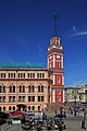 The city duma seen from Nevsky Prospekt.
 -
 The tower of the City Duma in the 1890s
 -
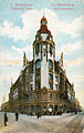 City Institutions Building on Sadovaya Street (1905–06)
 -
 The City Duma tower in New Year decorations at night


.jpg)