
Samnaun Alps
| Samnaun Alps | |
|---|---|
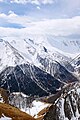
 Muttler (left) and Piz Tschütta (right) | |
| Highest point | |
| Peak | Muttler |
| Elevation | 3,293 m (10,804 ft) |
| Coordinates | 46°54′1″N 10°22′42″E / 46.90028°N 10.37833°E |
| Geography | |

| |
| Countries | Austria and Switzerland |
| States | Graubünden |
| Parent range | Central Eastern Alps |
| Borders on | Verwall Alps, Silvretta, Sesvenna Range and Ötztal Alps |
The Samnaun Alps are a
Graubünden canton of Switzerland
.
The Samnaun Alps are separated from the
Paznauntal; from the Ötztal Alps in the east by the Inn
valley. All the range is drained by the river Inn, through the Trisanna, Schergenbach, Brancla and Fimbabach.
Peaks
The range includes the following peaks:
| Peak | Elevation (m/ft) | |
|---|---|---|
| Muttler | 3293 | 10,804 |
| Piz Tschütta | 3258 | 10,689 |
| Piz Mundin | 3146 | 10,322 |
Vesilspitze |
3115 | 10,220 |
| Piz Rots | 3097 | 10,161 |
| Vesulspitze | 3092 | 10,145 |
| Hexenkopf | 3038 | 9,968 |
| Piz Malmurainza | 3038 | 9,968 |
| Bürkelkopf | 3033 | 9,951 |
| Gemspleiskopf | 3017 | 9,899 |
| Furgler | 3004 | 9,856 |
| Rothbleiskopf | 2938 | 9,640 |
| Flimspitz | 2929 | 9610 |
| Grübelekopf | 2894 | 9495 |
| Palinkopf | 2864 | 9396 |
For a list of passes, see Passes of the Silvretta and Rätikon Ranges.
-
 Muttler from north
 -
 Fimbatal border crossing Switzerland and Austria
 -
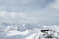 Piz Rots in the skiarea Silvretta Arena
 -
 Piz Mundin and Muttler from east (Nauders)

.jpg)


See also
- Swiss Alps
- List of mountains in Switzerland
Mountain ranges of the Central Eastern Alps according to the AVE | ||
|---|---|---|
|  | |
| International | |
|---|---|
| National | |