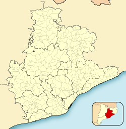
Sant Vicenç dels Horts
Sant Vicenç dels Horts | |
|---|---|
 Town hall | |
| Coordinates: 41°23′43″N 2°0′39″E / 41.39528°N 2.01083°E | |
| Country | |
| Community | |
| Province | Barcelona |
| Comarca | Baix Llobregat |
| Government | |
| • Mayor | Maite Aymerich i Boltà (2015)[1] (ERC) |
| Area | |
| • Total | 9.1 km2 (3.5 sq mi) |
| Elevation | 22 m (72 ft) |
| Population (2018)[3] | |
| • Total | 27,901 |
| • Density | 3,100/km2 (7,900/sq mi) |
| Website | www |
Sant Vicenç dels Horts (Catalan pronunciation: Iberic village are visible at Puig Castellar.
The
Baixador de Vallvidrera station, a distance of 13.6 kilometres (8.5 mi), whilst stage 20 links southwards to Bruguers, a distance of 16.2 kilometres (10.1 mi).[4]
Demography
| 1900 | 1930 | 1950 | 1970 | 1986 | 2002 |
|---|---|---|---|---|---|
| 1809 | 1919 | 3295 | 14,509 | 20,397 | 26,008 |
References
- Generalitat of Catalonia. Retrieved 2015-11-13.
- Statistical Institute of Catalonia. Retrieved 2015-11-23.
- ^ Municipal Register of Spain 2018. National Statistics Institute.
- ^ "GR 92: Sender de la Mediterrània" [GR 92: Mediterranean Path]. www.catalunya.com (in Catalan). Archived from the original on 7 November 2022. Retrieved 7 November 2022.
- Panareda Clopés, Josep Maria; Rios Calvet, Jaume; Rabella Vives, Josep Maria (1989). Guia de Catalunya, Barcelona: Caixa de Catalunya. ISBN 84-87135-02-1(Catalan).
External links
- Government data pages (in Catalan)


