
Saratoga National Historical Park
| Saratoga National Historical Park | |
|---|---|
 | |
  | |
| Location | Stillwater, Saratoga County, New York, United States |
| Nearest city | Saratoga Springs, New York |
| Coordinates | 42°59′56″N 73°38′15″W / 42.99889°N 73.63750°W |
| Area | 3,392 acres (13.73 km2) |
| Established | June 1, 1938 |
| Visitors | 65,043 (in 2011)[1] |
| Governing body | National Park Service |
| Website | Saratoga National Historical Park |
Saratoga National Historical Park | |
| NRHP reference No. | 66000569[2] |
| Added to NRHP | October 15, 1966 |
Saratoga National Historical Park is a United States
Description
The park preserves the site of the
First authorized as a
The Visitors Center offers a 20-minute orientation film,
The park is located on the upper Hudson River southeast of Saratoga Springs. It contains the famous Boot Monument to Benedict Arnold, the only war memorial in the United States that does not bear the name of its honoree. The memorial was donated by John Watts de Peyster, a former major general for the New York State Militia during the American Civil War who wrote several military histories about the Battle of Saratoga.
Saratoga Surrender Site Memorial Park

In 2021, management of the site where the British Army surrendered was transferred to the National Park Service.[4][5] The Saratoga Surrender Site Memorial Park marks the precise location where British General John Burgoyne surrendered his army to General Horatio Gates on October 17, 1777.[4] The 19-acre park is located nine miles north of the Saratoga Battlefield Park, and a half mile south of Schuylerville on U.S. Route 4.[4] The park includes explanatory plaques and signage, and two cannon.
The land is owned by the Open Space Institute and managed by the National Park Service, and is open to visitors from dawn to dusk year-round.[4]
Nearby Battles of Saratoga locations not included in the SNHP
The
During the closing days of the Battles of Saratoga, Baroness Riedesel sheltered there together with the wives of officers of the British army and wounded personnel. Her account of the travails of those around her, her keen insight into the personalities of the principal officers of both the British and American armies and her devotion to her husband in peril have led some commentators to name her as the first woman war correspondent. The Marshall House was bombarded by the Americans who supposed it an enemy headquarters.
Within are conserved cannonballs and other reminders of the ordeal suffered by those who took refuge there. The Marshall House is the sole surviving structure in the battles' area. The property is privately owned.
As of mid-2023, the American Battlefield Trust and its partners have acquired and preserved 26 acres of the battlefield outside of the national park.[6]
Gallery
-
 View of the battlefield
 -
 Trophy Cannon from the Battle of Saratoga
 -
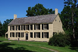 General Philip Schuyler House
 -
 Masonic Saratoga Monument
 -
 View from middle level of monument
 -
 View from top of monument
 -
 View from top of monument


References
- ^ "National Park Service Visitor Use Statistics". National Park Service. Retrieved October 6, 2012.
- ^ "National Register Information System". National Register of Historic Places. National Park Service. July 9, 2010. Retrieved July 17, 2013.
- ISBN 9781786845689.)
{{cite book}}: CS1 maint: location missing publisher (link - ^ a b c d "Management of OSI's Saratoga Surrender Site Added to Saratoga National Historical Park". Open Space Institute. Saratoga, New York. September 23, 2021. Retrieved July 23, 2022.
- ^ NPT Staff (March 23, 2021). "Saratoga Surrender Site Now Part Of Saratoga National Historical Park". National Parks Traveler. Retrieved July 23, 2022.
- ^ "Saratoga Battlefield". American Battlefield Trust. Retrieved June 19, 2023.
Further reading
- Lossing, Benson J. Pictorial Field-Book of the Revolution, I. 1850.
- Stone, William L., translator. Letters and Journals relating to the War of the American Revolution, and the Capture of the German Troops at Saratoga, by Mrs. General Riedesel. Joel Munsell, Albany, N.Y., 1867.