
Schierke
Schierke | |
|---|---|
Stadtteil of Wernigerode | |
 View from Wurmberg | |
 Coat of arms | |
Location of Schierke  | |
 Schierke  Schierke | |
| Coordinates: 51°45′50″N 10°39′53″E / 51.76389°N 10.66472°E | |
| Country | Germany |
| State | Saxony-Anhalt |
| District | Harz |
| Town | Wernigerode |
| Area | |
| • Total | 40.13 km2 (15.49 sq mi) |
| Elevation | 610 m (2,000 ft) |
| Population (2006-12-31) | |
| • Total | 721 |
| • Density | 18/km2 (47/sq mi) |
| Time zone | UTC+01:00 (CET) |
| • Summer (DST) | UTC+02:00 (CEST) |
| Postal codes | 38879 |
| Dialling codes | 039455 |
| Vehicle registration | HZ |
| Website | www.schierke-am-brocken.de |
Schierke is a village and a former municipality in the
Geography

Location
The
Today Schierke again is a popular place to start or finish a walk to the
-Deutschland.png)
Climate
The average air temperature in Schierke is 5.3 °C, and it has an annual precipitation of 1,275 millimetres.
History

The field name of Schierke was first mentioned in the records in 1590 as Schiriken (the
On 20 June 1898 Schierke was connected to
After World War II, however, due to its location next to the inner German border, Schierke for a long time was not accessible to the public for winter sports. Visits required an extra permission by East German authorities between 1952 and 1989. Several hotels were converted into public holiday resorts of the Free German Trade Union Federation (FDGB) and of the Stasi ministry. Barracks for the Border Troops of the German Democratic Republic stood on the site of the present training centre for engineering and metallurgy. The 7th Border Company of the 20th Border Regiment guarded the stretch of border from the Brocken plateau via former Goetheweg station and the Dreieckiger Pfahl border stone (checkpoint no. 168 in the Harzer Wandernadel) to the Großer Winterberg. Each troop was stationed for a week at a time in the present-day station building on the peak of the Brocken.
After German reunification, tourism again prospered and many villas were restored. On 13 January 2009 Mayor Hans-Jochen Ermisch, and his counterpart from Wernigerode, Peter Gaffert, signed the treaty incorporating Schierke into Wernigerode.[2] This merger came into effect on 1 July 2009.[3] Since then, the Wernigerode town council has made comprehensive efforts to develop Schierke as a resort town.
Politics
Coat of arms
The coat of arms was granted to Schierke on 5 May 1939 by the governor (Oberpräsident) of the Province of Saxony.
The stag's antlers epitomize the "King of the Harz Forest", the dominant wild animal in the mountain forests around Schierke. Just as the antlers are the crown of the deer, Schierke, on the Brocken, "crowns" the Harz landscape with its natural beauty and its healing climate.
The coat of arms was designed by the head of the Magdeburg state archives, Otto Korn.
Memorials
- Grave site on the village cemetery (Ortsfriedhof) for an unknown Second World War.
Places of interest
- Brocken, highest mountain in the Harz, accessible daily on the Brocken Railway
- Wurmberg, highest mountain in Lower Saxony
- Feuersteinklippencrags
- Schnarcherklippen crags
- "Apotheke zum Roten Fingerhut" – "Red Thimble" chemist's
- Schierke Mountain Church (Schierker Bergkirche)
Sport and hiking
The area around Schierke is criss-crossed by numerous trails, several leading up to the top of the Brocken. There is a choice of longer or shorter, but usually steeper, walks. The Wurmberg Trail (Wurmbergstieg) runs up to the summit of the Wurmberg. From the station, a trail runs directly to the tor known as the Feuersteinklippe. For winter sports lovers, Schierke has an extensive cross-country skiing trail network and a natural ice rink.
In the first half of the 20th century Schierke was known for its
In Schierke there is a
-
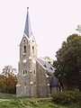 Schierke Mountain Church
 -
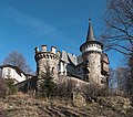 Schierke Castle at the head of the Elend valley
 -
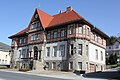 Schierke village hall


Notable people
Schierker Feuerstein

References
- ^ German Met Office, normal periods 1961-1990
- ^ Schierke und Wernigerode freuen sich. MDR Info, 13. Januar 2009
- Statistisches Bundesamt
External links
Town of Wernigerode | ||
|---|---|---|
| International | |
|---|---|
| National | |