
Sint Odiliënberg
Sint Odiliënberg | ||
|---|---|---|
Village | ||
Roer river | ||
|
Postal code 6077[1] | ||
| Dialing code | 0475 | |
| Major roads | N293 | |
Sint Odiliënberg (Dutch pronunciation:
History
The village was first mentioned in the first half of the 9th century as Mons Petri. The current name means "hill of Odile of Alsace".[3]
After the Eighty Years' War, this area came under Spanish rule; it was ceded to the Dutch Republic in 1715. Until the French municipal reorganisation, St. Odiliënberg belonged to the administrative division known as Ambt Montfort. Around 1810 it became a separate commune/municipality. In 1991 the municipality of Sint Odiliënberg merged into Ambt Montfort, which in January 2007 merged into Roerdalen.
Attractions
Standing on a hill is a Romanesque basilica with two towers dating from the eleventh century. Next to the basilica is a 10th-century chapel, originally the parish church.
Gallery
-
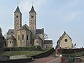 Sint Odiliënberg, basilica
 -
 Sint Odiliënberg, windmill: molen van Verbeek


Notable residents
- Connie Palmen, writer, born in St. Odiliënberg
- Geert Chatrou, professional whistler, born in St. Odiliënberg
References
- ^ a b c "Kerncijfers wijken en buurten 2021". Central Bureau of Statistics. Retrieved 25 April 2022.
- ^ "Postcodetool for 6077AA". Actueel Hoogtebestand Nederland (in Dutch). Het Waterschapshuis. Retrieved 25 April 2022.
- ^ a b "Sint Odiliënberg - (geografische naam)". Etymologiebank (in Dutch). Retrieved 25 April 2022.