
Sister Bay, Wisconsin
Sister Bay, Wisconsin | ||
|---|---|---|
FIPS code 55-74225[5] | | |
| GNIS feature ID | 1574209[2] | |
| Website | http://www.sisterbay.com/ | |
Sister Bay is a village in
Geography
According to the United States Census Bureau, the village has a total area of 3.58 square miles (9.27 km2), of which 2.58 square miles (6.68 km2) is land and 1.00 square mile (2.59 km2) is water.[7]
Demographics
| Census | Pop. | Note | %± |
|---|---|---|---|
| 1920 | 190 | — | |
| 1930 | 238 | 25.3% | |
| 1940 | 309 | 29.8% | |
| 1950 | 429 | 38.8% | |
| 1960 | 520 | 21.2% | |
| 1970 | 483 | −7.1% | |
| 1980 | 564 | 16.8% | |
| 1990 | 675 | 19.7% | |
| 2000 | 886 | 31.3% | |
| 2010 | 876 | −1.1% | |
| 2019 (est.) | 935 | [4] | 6.7% |
| U.S. Decennial Census[8] | |||
2000 census
At the 2000
There were 446 households, of which 11.4% had children under the age of 18 living with them, 46.0% were married couples living together, 3.6% had a female householder with no husband present, and 49.6% were non-families. 46.4% of all households were made up of individuals, and 28.7% had someone living alone who was 65 years of age or older. The average household size was 1.78 and the average family size was 2.45.
10.9% of the population were under the age of 18, 3.7% from 18 to 24, 13.4% from 25 to 44, 25.7% from 45 to 64, and 46.2% who were 65 years of age or older. The median age was 61 years. For every 100 females, there were 73.7 males. For every 100 females age 18 and over, there were 69.0 males.
The
2010 census
At the 2010
There were 457 households, of which 11.2% had children under the age of 18 living with them, 40.3% were married couples living together, 5.0% had a female householder with no husband present, 2.2% had a male householder with no wife present, and 52.5% were non-families. 47.3% of all households were made up of individuals, and 29.7% had someone living alone who was 65 years of age or older. The average household size was 1.75 and the average family size was 2.43.
The median age in the village was 62.7 years. 10.3% of residents were under the age of 18; 3.2% were between the ages of 18 and 24; 15% were from 25 to 44; 25.3% were from 45 to 64; and 46.2% were 65 years of age or older. The gender makeup of the village was 42.9% male and 57.1% female.

Education
Gibraltar Area Schools serves the community. Gibraltar Elementary School[9] and Gibraltar Secondary School[10] are the two schools.
Historical landmarks
- Jischke's Meat Market
- Al Johnson's Swedish Restaurant
- The shipwreck site of the Meridian, a schooner that sank in 1873, is located off the coast of Sister Bay south of the Sister Islands.
- Country House Resort, was the first homestead in Sister Bay, Door County, Wisconsin. The Town of Liberty Grove was established at a meeting on this property in 1859.
Transportation
State highways
 WIS 42 northbound travels to Ellison Bay, and Gills Rock, while southbound travels to Ephraim, Sturgeon Bay, and Manitowoc, where it connects to I-43.
 WIS 57 terminates in Sister Bay; southbound travels to Sturgeon Bay and Green Bay, where it connects to I-43.

Climate
| ||||||||||||||||||||||||||||||||||||||||||||||||||||||||||||||||||||||||||||||||||||||||||||||||||||||||||||||||||||||||||||
Images
-
 Sister Bay, circa 1912. Sister Bay Hotel is on left.
 -
 Looking south at Sister Bay sign
 -
 Post office
 -
![Sister Bay Beach; a study conducted from May through August 2019 found it was the most visited beach in the county.[12]](//upload.wikimedia.org/wikipedia/commons/thumb/a/af/Sister_Bay_Beach_in_Sister_Bay_Wisconsin.jpg/771px-Sister_Bay_Beach_in_Sister_Bay_Wisconsin.jpg) Sister Bay Beach; a study conducted from May through August 2019 found it was the most visited beach in the county.[12]
Sister Bay Beach; a study conducted from May through August 2019 found it was the most visited beach in the county.[12] -
 Breakwater for the Sister Bay Marina
 -
 Sister Bay, published 1899
 -
 Pebble Beach at Little Sister Bay, postmarked 1904
 -
 Postcard from around the 1930s or 1940s
 -
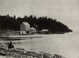
 Northwestern side of the village
.jpg)


![Sister Bay Beach; a study conducted from May through August 2019 found it was the most visited beach in the county.[12]](/File:Sister_Bay_Beach_in_Sister_Bay_Wisconsin.jpg)


.png)
References
- ^ "2019 U.S. Gazetteer Files". United States Census Bureau. Retrieved August 7, 2020.
- ^ a b "US Board on Geographic Names". United States Geological Survey. October 25, 2007. Retrieved January 31, 2008.
- ^ a b "U.S. Census website". United States Census Bureau. Retrieved November 18, 2012.
- ^ a b "Population and Housing Unit Estimates". United States Census Bureau. May 24, 2020. Retrieved May 27, 2020.
- ^ a b "U.S. Census website". United States Census Bureau. Retrieved January 31, 2008.
- ^ Map of the Village of Sister Bay, Door County Land Use Services Department, December 11, 2018, (Archived April 9, 2019)
- ^ "US Gazetteer files 2010". United States Census Bureau. Retrieved November 18, 2012.
- ^ "Census of Population and Housing". Census.gov. Retrieved June 4, 2015.
- ^ Gibraltar Elementary School, gibraltar.k12.wi.us
- ^ Gibraltar Elementary School, gibraltar.k12.wi.us
- ^ "NASA EarthData Search". NASA. Retrieved January 30, 2016.
- ^ Economic Value of Reengineering WI Great Lakes beaches by Matthew Winden, UW-Whitewater Fiscal & Economic Research Center Institute for Water Business, page 10
External links
Adjacent communities near Sister Bay, Wisconsin | ||||||||||||||||
|---|---|---|---|---|---|---|---|---|---|---|---|---|---|---|---|---|
| ||||||||||||||||
| International | |
|---|---|
| National | |
| Geographic | |