
Somalia–Somaliland border
This article needs additional citations for verification. (July 2021) |
| Somaliland–Somalia border | |
|---|---|
.jpg) British Somaliland and Italian Somaliland border by Anglo-Italian Boundary Commission, 1929–1930 | |
| Characteristics | |
| Entities | |
| Length | 407 kilometers (253 mi) |
| History | |
| Established | 1894 |
| Current shape | 1929 (Somaliland's claim) |
| Treaties | Somaliland. Anglo-Italian Boundary Treaty.[1] |
The Somalia–Somaliland border (
History
Anglo-Italian Boundary Treaty era (1894 and 1960)

In May 1894, the border between Somaliland and Somalia was demarcated by the Anglo-Italian.[6][7][8] Officially implemented in 1929, it extends along longitude 49 (49E), from the Gulf of Aden to 9°N latitude, and then diagonally across the intersection of longitude 48 (48E) and 8N latitude. West along 8N latitude which is the beginning of the border between Somaliland and Ethiopia.[9]
The names of the villages that are close to the border:
- A1 Hills (A1 Mado)
- Bunda Ziada
- Bosaso or Bender Casim (Italian)
- Hegligab (Higle-Gab)
- Sorl Hand
- Darror
- Hauratiroh
- Marojeh
- Khumberl (E1 Gumbuhul)
- Hobat
- Dugaan
- E1 Dibr
- Galweineh
- Darado
- Wareigleh
Restoration of sovereignty (1991)
After a long
According to the constitution voted for by the people of Somaliland, the border between Somaliland and Somalia is the border of the State of Somaliland which gained independence on May 26, 1960.[13]
Disputed territory
The Puntland state disputes the Sool and Sanaag regions, as well as parts of Togdheer.
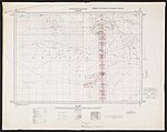
Historical maps
Historical maps of the border from north to south in the International Map of the World.
- between Somalia Italia and State of Somaliland
-
 full limits
 -

-
-

-

-

-

.jpg)
.jpg)
.jpg)
.jpg)
.jpg)
.jpg)
See also
References
- JSTOR 1784441.
- ^ https://africaoilcorp.com/site/assets/files/1267/2012_aif.pdf [bare URL PDF]
- ^ "Averting War in Northern Somalia". 27 June 2018.
- ^ "Puntland vows to reject outcome of FGS-Somaliland talks, wants new electoral law nullified". 30 June 2020.
- ^ Encyclopædia Britannica, The New Encyclopædia Britannica, (Encyclopædia Britannica: 2002), p.835
- ^ https://jgs.lyellcollection.org/content/jgsleg/87/1-4/local/front-matter.pdf [bare URL PDF]
- ^ "Anglo-Italian Relations in the Middle East, 1922–1940". 13 September 0418.
- JSTOR 1784441.
- ^ "Somaliland Boundaries".
- ^ "Somaliland: 25 years as an unrecognised state".
- ^ "Somaliland | historical region, Africa".
- ^ "Somaliland: 30 Years of de Facto Statehood, and No End in Sight". 7 May 2021.
- ^ "Elections in Somaliland". africanelections.tripod.com. Retrieved 2020-06-20.