
Sorell, Tasmania
| Sorell Federal division(s) | Lyons | |
|---|---|---|
Sorell is a town in
History
Sorell was named after William Sorell, the third Lieutenant-Governor of Van Diemen's Land. Historically, it was known as a major town on the route from Hobart to Port Arthur on the Tasman Peninsula. It was the centre of an agricultural area and an important market town. It is now a dormitory town of Hobart, as well as the seat of the Sorell Council.
In 1872 the Sorell Causeway was opened, from the Cambridge direction, across Pitt Water and Orielton Lagoon to Sorell, stopping at Midway Point in the middle. This shortened the route considerably from the original road via Richmond.
Sorell Post Office opened on 1 June 1832.[6]
There is also a mountain in the
Infrastructure
Sorell is served by
Sorell Plaza shopping centre, built in the mid 2000s, provides a supermarket and other major retail outlets. It was purchased by SCA Property Group, a subsidiary of Woolworths, in 2019.[8] Gateway Shopping Center includes a competing supermarket and small retail.
Sorell is served by private bus companies, Tassielink Transit and Redline Coaches.
Sorell falls within the Anglican Parish of South East Tasmania, based at St George's Church, and the Parish of Richmond, with services at St Thomas's Church. Historically, it was also served by the Presbyterian Scots Church, designed by James Blackburn, which is now a private residence.[9]
Sorell has a number of historic buildings, including the Sorell Barracks, constructed to house soldiers during the Black War. These and other historic buildings - including the railway house, the old Sorell Library (now an antiques centre), and the Gordon Highlander Hotel, form a heritage walk.[10] The area also has a local historical society[11] as well as a Freemasons Lodge (Lodge Pembroke).[12]
Gallery
-
 Sorell Causeway
 -
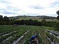 Berry farm near Sorell
 -
 Aerial photo


References
- ^ Australian Bureau of Statistics (28 June 2022). "Sorell (suburb and locality)". Australian Census 2021 QuickStats. Retrieved 28 June 2022.
- ^ "Visitor Information - Sorell Council".
- ^ Australian Bureau of Statistics (25 October 2007). "Sorell (State Suburb)". 2006 Census QuickStats. Retrieved 23 November 2011.
- ^ Australian Bureau of Statistics (31 October 2012). "Sorell (State Suburb)". 2011 Census QuickStats. Retrieved 7 January 2012.
- ^ Australian Bureau of Statistics (27 June 2017). "Sorell (State Suburb)". 2016 Census QuickStats. Retrieved 24 December 2017.
- ^ Premier Postal History. "Post Office List". Premier Postal Auctions. Retrieved 16 June 2012.
- ^ "Pioneer School - Sorell History Society". Sorell History Society. Retrieved 4 November 2021.
- ^ Johanson, Simon (6 August 2019). "SCA digests Vicinity's malls but profit falls". The Sydney Morning Herald. Retrieved 4 November 2021.
- ^ "Sorell, TAS". Aussie Towns. Aussie Towns. Retrieved 4 November 2021.
- ^ "Sorell Heritage Walk" (PDF). Sorell Council. Retrieved 4 November 2021.
- ^ "Sorell History Society | researching and recording the history of the Sorell Municipality".
- user-generated source]
