
Matadi: Difference between revisions
Content deleted Content added
KolbertBot (talk | contribs) m Bot: HTTP→HTTPS (v478) |
Rescuing 1 sources and tagging 0 as dead. #IABot (v1.6.2) |
||
| Line 39: | Line 39: | ||
[[File:108 Matadi. - Le marche.jpg|thumb|left|The market, 1899]] |
[[File:108 Matadi. - Le marche.jpg|thumb|left|The market, 1899]] |
||
Matadi was founded by [[Sir Henry Morton Stanley]] in 1879. It was strategically important because it was the last navigable port on the [[Congo River]] and therefore the furthest inland port in the [[Congo Free State]]. The construction of the [[Matadi–Kinshasa Railway]] (built between 1890 and 1898) made it possible to transport goods from deeper within Congo's interior to the port of Matadi and the city became an important trading center. Portuguese and French West-African commercial interests influenced the city's architecture and urban design which borrowed from the neighboring colonies in [[Angola]] and the [[Congo-Brazzaville]].<ref>History of architecture: city, architecture and |
Matadi was founded by [[Sir Henry Morton Stanley]] in 1879. It was strategically important because it was the last navigable port on the [[Congo River]] and therefore the furthest inland port in the [[Congo Free State]]. The construction of the [[Matadi–Kinshasa Railway]] (built between 1890 and 1898) made it possible to transport goods from deeper within Congo's interior to the port of Matadi and the city became an important trading center. Portuguese and French West-African commercial interests influenced the city's architecture and urban design which borrowed from the neighboring colonies in [[Angola]] and the [[Congo-Brazzaville]].<ref>History of architecture: city, architecture and |
||
colonial space in Matadi and Lubumbashi, Sofie Boonen, http://symposium.fea.ugent.be/sites/symposium.elis.ugent.be/files/phdsymposium/paper450abstract_42.pdf</ref> |
colonial space in Matadi and Lubumbashi, Sofie Boonen, {{cite web |url=http://symposium.fea.ugent.be/sites/symposium.elis.ugent.be/files/phdsymposium/paper450abstract_42.pdf |title=Archived copy |accessdate=2014-07-11 |deadurl=yes |archiveurl=https://web.archive.org/web/20140714203329/http://symposium.fea.ugent.be/sites/symposium.elis.ugent.be/files/phdsymposium/paper450abstract_42.pdf |archivedate=2014-07-14 |df= }}</ref> |
||
== Culture == |
== Culture == |
||
Revision as of 07:59, 21 January 2018
Matadi | |
|---|---|
UTC+1 |
Matadi is the chief sea port of the
Sir Henry Morton Stanley
in 1879.
History

Matadi was founded by
Congo-Brazzaville.[1]
Culture
The word Matadi means stone in the local
Kikongo language. The town is built on steep hills and there is local saying that to live in Matadi, you must know the verbs "to go up", "to go down" and "to sweat". Upstream is a series of caves known as the "rock of Diogo Cão", after graffiti
carved by the Portuguese explorer in 1485 marking the limit of his travels up the Congo River.
Yelala Rapids
also lie near the city.
Climate
| Climate data for Matadi | |||||||||||||
|---|---|---|---|---|---|---|---|---|---|---|---|---|---|
| Month | Jan | Feb | Mar | Apr | May | Jun | Jul | Aug | Sep | Oct | Nov | Dec | Year |
| Mean daily maximum °C (°F) | 33 (91) |
33 (92) |
34 (94) |
34 (93) |
33 (91) |
30 (86) |
28 (83) |
29 (84) |
30 (86) |
32 (90) |
33 (91) |
32 (90) |
32 (89) |
| Mean daily minimum °C (°F) | 24 (76) |
24 (76) |
24 (76) |
24 (76) |
24 (75) |
22 (71) |
20 (68) |
21 (69) |
22 (72) |
24 (75) |
24 (75) |
24 (75) |
23 (74) |
| Average precipitation cm (inches) | 13 (5) |
11 (4.3) |
17 (6.6) |
19 (7.4) |
6.1 (2.4) |
0.25 (0.1) |
0.25 (0.1) |
0.25 (0.1) |
0.76 (0.3) |
2.8 (1.1) |
17 (6.7) |
15 (5.8) |
101 (39.8) |
| Source: Weatherbase[2] | |||||||||||||
Infrastructure
.jpg)
The mouth of the Congo forms one of Africa's largest harbours. In addition to Matadi which is the furthest upriver, three ports are located within it, the others being
Tshimpi Airport is nearby but is reportedly inactive.[citation needed
]
Matadi-Kinshasa Railway constructed to bypass the rapids on the river upstream. A monument to the builders of the railway stands on a nearby hill.[citation needed
]
A power station on the M'pozo River supplies power to Matadi.[citation needed]
Port

The maximum draft of the port is 8.2m.[3] The Navy of the Democratic Republic of the Congo maintains one operational command at the port.
Media
La Cité africaine de Matadi is a newspaper published in Matadi.[4]
Gallery
-
 Matadi, 1899
 -
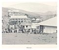
 The market, 1899
 -
 A corner market in Matadi, 1899
 -
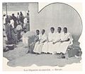 Women at the market in Matadi, 1899
 -
 The market, 1899
 -
 The houses of Matadi, 1899
 -
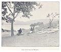 The surroundings of Matadi, 1899
 -
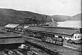 Matadi port, circa 1942
 -
 Full Congo River at Matadi and the first rapids
 -
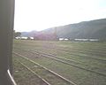 Arrival at Matadi station
 -
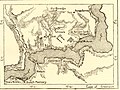 Map of Matadi and Vivi around 1890
 -
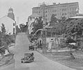 Matadi in 1930s


References
- ^ History of architecture: city, architecture and
colonial space in Matadi and Lubumbashi, Sofie Boonen, "Archived copy" (PDF). Archived from the original (PDF) on 2014-07-14. Retrieved 2014-07-11.
{{cite web}}: Unknown parameter|deadurl=ignored (|url-status=suggested) (help)CS1 maint: archived copy as title (link) - ^ "Weatherbase: Historical Weather for Matadi, Democratic Republic of the Congo". Weatherbase. 2011. Retrieved on November 24, 2011.
- ^ http://www.e-ships.net/ports/Congo%20(Democratic%20Republic)/1148.htm
- ^ "Countries: Democatric Republic of the Congo: News" (Archive). [sic] Stanford University Libraries & Academic Information Resources. Retrieved on April 28, 2014.
External links
Wikivoyage has a travel guide for Matadi.
05°49′00″S 13°29′00″E / 5.81667°S 13.48333°E
Capitals of the provinces of the Democratic Republic of the Congo | ||
|---|---|---|
|  | |
Provinces are shown between brackets | ||
| Cities | |
|---|---|
| Territories |
|
| Populated places | |
| Other | |