
St Botolph's Church, Ruxley
| St Botolph's | |
|---|---|
| St Botolph's Church | |
Scheduled ancient monument | |
| Years built | 13th century |
| Closed | 1557 |
| Administration | |
| Parish | Ruxley (before 1557 deconsecration), Hundred of Ruxley, Lathe of Sutton at Hone, Kent (North Cray after 1557) |
St Botolph's Church is a church building in
scheduled ancient monument on the grounds of Ruxley Manor Garden Centre, although many features are still intact, the church is in disrepair and English Heritage
have agreed to pay a grant to help preserve the building.
Location
Today St Botolph's Church is located to the east of Ruxley Wood, on the grounds of Ruxley Manor Garden Centre, within
Go Ahead London for Transport for London, serves the bus stops along Maidstone Road, on its journey from Eltham to Swanley passing through Ruxley.[2]
History
Archaeological work was carried out in the 1960s found evidence of an older wooden building on the site, suggesting there may have been an older Saxon church in the same location.deconsecrated by Cardinal Reginald Pole ,[3] when the parish of Ruxley was abolished and the land and population absorbed into North Cray parish to the north.[8] The church was used as a farm building for over 400 years to store agricultural equipment.[3]
Today the church is a
scheduled ancient monument[3] on the grounds of Ruxley Manor Garden Centre,[1][3] and is owned by the Evans family.[3] Although many features are still intact, including the majority of the roof, the church is in disrepair, and appears as "remains of church" on Ordnance Survey maps.[1] English Heritage have agreed to pay a grant of £35,000 of the estimated £62,000 needed for structural work on the building to help preserve it.[3]
Gallery
-
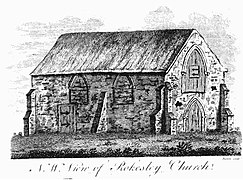 "N.W. view of Rokesley Church" Engraving of St Botolph's Church, Ruxley, appearing in The History and Topographical Survey of the County of Kent: Volume 2. by Edward Hasted
 -
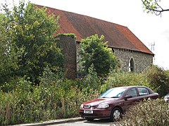 Church and oast house, August 2001
 -

-

-

-


Wikimedia Commons has media related to St Botolph's Church, Ruxley.
References
- ^ a b c d Ruxley church marked on Ordnance Survey map, accessed from Streetmap.co.uk
- ^ 233 bus route map and bus stop list, accessed from tfl.gov.uk
- ^ a b c d e f g h News Shopper Bexley Preservation cash for former church news article about English Heritage grant for St Botolph's Church, Ruxley. accessed from www.newsshopper.co.uk
- ^ Ruxley's entry in the Domesday Book (1086) accessed from OpenDomesday.org
- ^ a b c Edward Hasted, 'The hundred of Ruxley: Introduction', in The History and Topographical Survey of the County of Kent: Volume 2 (Canterbury, 1797), pp. 1–2. Hundred of Ruxley entry accessed from British History Online (accessed 30 March 2016).
- ISBN 1-86077-255-2– Map and description of meeting places & hundreds p. 30
- ^ Hundred of Ruxley (Helmestrei) entry in the Domesday Book (1086) accessed from OpenDomesday.org
- ^ Edward Hasted, 'Parishes: North Cray with Ruxley', in The History and Topographical Survey of the County of Kent: Volume 2 (Canterbury, 1797), pp. 141–162. accessed from British History Online