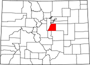
Stonegate, Colorado
Stonegate, Colorado | |
|---|---|
303 & 720 | |
| GNIS feature[2] | Stonegate CDP |
Stonegate is an
United States Census 2020.[3] The Stonegate Village Metropolitan District provides services to the community, which lies in ZIP Code 80134.[4]
Geography
Stonegate is located in northeastern Douglas County. It is bordered to the east by the town of Parker and to the west by unincorporated Grand View Estates.
The E-470 toll road around the eastern side of the Denver-Aurora metropolitan area forms the northern edge of Stonegate, with access from Exits 3 and 4. Downtown Denver is 21 miles (34 km) to the northwest.
The Stonegate CDP has an area of 1,180 acres (4.777 km2), including 7.9 acres (0.032 km2) of water.[1]
Demographics
The
United States Census 2000
.
| Year | Pop. | ±% |
|---|---|---|
| 2000 | 6,284 | — |
| 2010 | 8,962 | +42.6% |
| 2020 | 9,072 | +1.2% |
| Source: United States Census Bureau | ||
Education
The Douglas County School District serves Stonegate.
See also
- Outline of Colorado
- State of Colorado
- Colorado cities and towns
- Colorado census designated places
- Colorado counties
- List of statistical areas in Colorado
- Front Range Urban Corridor
- North Central Colorado Urban Area
- Denver-Aurora-Boulder, CO Combined Statistical Area
- Denver-Aurora-Broomfield, CO Metropolitan Statistical Area
References
- ^ a b c "State of Colorado Census Designated Places - BAS20 - Data as of January 1, 2020". United States Census Bureau. Retrieved December 21, 2020.
- ^ a b c "U.S. Board on Geographic Names: Domestic Names". United States Geological Survey. Retrieved December 21, 2020.
- ^ a b United States Census Bureau. "Stonegate CDP; Colorado". Retrieved April 28, 2023.
- ^ a b "Zip Code 80134 Map and Profile". zipdatamaps.com. 2020. Retrieved December 21, 2020.

