
Strait of El Río
| El Río | |
|---|---|
La Graciosa | |
| Coordinates | 29°13′19″N 13°30′02″W / 29.22194°N 13.50056°W |
| Type | Strait |
| Etymology | the river |
| Ocean/sea sources | Atlantic Ocean |
| Basin countries | Spain |
| Designation | Part of the marine reserve established around La Graciosa and the islets north of Lanzarote |
| Min. width | 1.1 km (0.68 mi; 0.59 nmi) |
| Settlements | Caleta de Sebo |
El Río (
, means 'river'. At its narrowest point, the strait is just over 1.1 kilometres (0.68 mi; 0.59 nmi) wide.El Río is part of the marine reserve established around La Graciosa and the islets north of Lanzarote.[2]
Points of Interest
Overlooking the strait from the southeastern shore are the cliffs of Famara, on the island of Lanzarote.
One of local artist César Manrique's creations, Mirador del Río, consists of a viewpoint located at a height of 400 metres (1,300 ft) on the cliffs of Famara. The viewpoint overlooks onto La Graciosa and the rest of the Chinijo Archipelago across the strait of El Río, after which the viewpoint is named.[3]
The
-
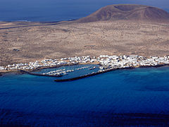 Caleta de Sebo
 -
 Cliffs of Famara
 -
 Mirador del Río
 -
 Salinas del Río


Ferries
The only way to get to the island of
As of July 2019, two ferry companies operate this service, both based on La Graciosa: Líneas Romero and Biosfera Express.[5][6] Travel time is about 25 minutes.[5]
Open Water Swimming
The Travesía a nado "El Río" is an annual
References
- ^ El Río can be found at GEOnet Names Server, at this link, by opening the Advanced Search box, entering " -381178 " in the "Unique Feature Id" form, and clicking on "Search Database".
- ^ "Orden de 19 de mayo de 1995 por la que se establece una reserva marina en el entorno de la Isla Graciosa y de los islotes del norte de Lanzarote" [Order of 19 May 1995 by which a marine reserve is established around Graciosa island and the islets north of Lanzarote] (in Spanish). BOE. 1995-06-02. Retrieved 2019-07-30.
- ^ "Mirador del Río". Centres for Arts, Culture and Tourism of Lanzarote. Retrieved 2019-07-30.
- ^ "Arranca la restauración de las Salinas del Río, "las más antiguas de Canarias"" [The restoration of the Salinas del Río, the oldest of the Canary Islands, begins] (in Spanish). Diario de Lanzarote. 2018-08-07. Retrieved 2019-07-30.
- ^ a b "Schedule and routes". Líneas Romero. Retrieved 2019-07-30.
- ^ "Biosfera Express". Retrieved 2019-07-30.
- ^ "Travesía a nado 'EL RÍO' (Lanzarote-La Graciosa)" ['EL RÍO' swim crossing (Lanzarote-La Graciosa)] (in Spanish). Cabildo de Lanzarote. 2018-10-14. Retrieved 2019-07-30.