
Studsgade
Latin Quarter, Aarhus, Denmark | |
| Postal code | 8000 |
|---|---|
| Coordinates | 56°09′35.5″N 10°12′39.4″E / 56.159861°N 10.210944°E |
Studsgade is a street in
In the middle of Studsgade lies the small square Rykind from where the narrow alley Snævringen leads to Mejlgade.
History
Studsgade was the northern inroad to the
Studsgade may have had a city gate in the direction of Grenå, but in the 1700s it had been moved to the site of the current Aarhus School of Architecture. In 1757, a new road was opened from Studsgade to Christiansbjerg in the north, which funneled a lot of traffic from Munkegade's Port to Studsgade.[3] The increased traffic made Studsgade more useful for merchants, and several merchant's houses from that time can be found along the street today.
Listed buildings
Studsgade contains four listed buildings from 1700, 1749, 1842 and 1847, situated side by side by Nørreport. Three of the buildings are half-timbered, and the fourth is a 3 winged brick structure that used to house a factory.[4][5][6][7]
-
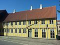 Studsgade 35, one of 4 listed buildings
 -
 Snevringen


References
- ^ "Studsgade" (in Danish). Aarhus City Archives. Archived from the original on 24 February 2016. Retrieved 16 February 2016.
- ^ "Gade Studsgade" (in Danish). Aarhus Municipality. Archived from the original on 1 April 2016. Retrieved 16 February 2016.
- ^ "Studsgadesport" (in Danish). Aarhus State Archives. Archived from the original on 23 February 2016. Retrieved 16 February 2016.
- Danish Heritage Agency. Archivedfrom the original on 23 February 2016. Retrieved 16 February 2016.
- Danish Heritage Agency. Archivedfrom the original on 23 February 2016. Retrieved 16 February 2016.
- Danish Heritage Agency. Archivedfrom the original on 23 February 2016. Retrieved 16 February 2016.
- Danish Heritage Agency. Archivedfrom the original on 23 February 2016. Retrieved 16 February 2016.
External links
- "Fredede Bygninger Marts 2018" [Listed Buildings March 2018] (PDF) (in Danish). Danish Agency for Culture and Palaces. Archived(PDF) from the original on 3 March 2018. Retrieved 3 March 2018.

