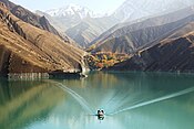
Sumbar Dam
| Sumbar Dam | |
|---|---|
North Khorasan Province | |
| Coordinates | 38°03′59.6″N 057°09′41.7″E / 38.066556°N 57.161583°E |
| Purpose | Flood control, municipal, irrigation water |
| Status | Operational |
| Dam and spillways | |
| Type of dam | Embankment, rock-fill |
| Height | 23 m (75 ft) |
| Length | 900 m (3,000 ft) |
| Elevation at crest | 1,342 m (4,403 ft) |
| Reservoir | |
| Total capacity | 16,200,000 m3 (13,100 acre⋅ft) |
The Sumbar Dam is a rock-fill
North Khorasan Province, Iran. The primary purpose of the dam is flood control and water supply for irrigation and municipal uses.[1]
See also
- Dams in Iran
References
- S2CID 109602394.

