Synoptic scale meteorology
 |
| Meteorology |
|---|
| Climatology |
| Aeronomy |
| Glossaries |
This article may be too technical for most readers to understand. (October 2023) |
In
The
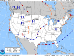
Surface weather analysis

A
The first weather maps in the 19th century were drawn well after the fact to help devise a theory on storm systems.
Surface weather analyses have special symbols which show frontal systems, cloud cover,
Extratropical cyclone
An extratropical cyclone is a synoptic scale
The descriptor "extratropical" refers to the fact that this type of cyclone generally occurs outside of the tropics, in the middle latitudes of the planet. These systems may also be described as "mid-latitude cyclones" due to their area of formation, or "post-tropical cyclones" where extratropical transition has occurred,[5][6] but are often described as "depressions" or "lows" by weather forecasters and the public. These are the everyday phenomena that, along with anticyclones, drive the weather over much of the Earth.
Although extratropical cyclones are almost always classified as
Surface high-pressure systems

High-pressure systems are frequently associated with light winds at the surface and
Strong, vertically shallow high-pressure systems moving from higher latitudes to lower latitudes in the northern hemisphere are associated with continental arctic air masses.
On weather maps, these areas show converging winds (isotachs), also known as
Weather fronts

A
Cold fronts and occluded fronts generally move from west to east, while warm fronts move poleward. Because of the greater density of air in their wake, cold fronts and cold occlusions move faster than warm fronts and warm occlusions. Mountains and warm bodies of water can slow the movement of fronts.[20] When a front becomes stationary, and the density contrast across the frontal boundary vanishes, the front can degenerate into a line which separates regions of differing wind velocity, known as a shearline. This is most common over the open ocean.
See also
References
- ^ "cyclonic scale". American Meteorological Society. Archived from the original on 28 April 2016. Retrieved 2017-01-21.
- ^ Air Apparent: How Meteorologists Learned to Map, Predict, and Dramatize Weather. University of Chicago PressChicago: 1999.
- ^ Eric R. Miller. American Pioneers in Meteorology. Retrieved on 2007-04-18.
- ^ Bureau of Meteorology. The Weather Map. Retrieved on 10 May 2007.
- ^ a b Dr. DeCaria (2005-12-07). "ESCI 241 – Meteorology; Lesson 16 – Extratropical Cyclones". Department of Earth Sciences, Millersville University, Millersville, Pennsylvania. Archived from the original on 2006-09-03. Retrieved 2006-10-21.
{{cite web}}: External link in|agency= - ^ Robert Hart and Jenni Evans (2003). "Synoptic Composites of the Extratropical Transition Lifecycle of North Atlantic TCs as Defined Within Cyclone Phase Space" (PDF). American Meteorological Society. Retrieved 2006-10-03.
{{cite web}}: External link in|agency= - ^ Ryan N. Maue. CHAPTER 3: CYCLONE PARADIGMS AND EXTRATROPICAL TRANSITION CONCEPTUALIZATIONS. Archived 2008-05-10 at the Wayback Machine Retrieved on 15 June 2008.
- NOAA. Retrieved 2006-07-25.
- NOAA. Retrieved on 2009-02-16.
- ^ Jack Williams (2007). What's happening inside highs and lows. USA Today. Retrieved on 2009-02-16.
- ^ Myanmar government (2007). Haze. Archived 2007-01-27 at the Wayback Machine Retrieved on 2007-02-11.
- NCARNational Research Laboratory. Retrieved on 2007-02-11.
- ^ CBC News (2009). Blame Yukon: Arctic air mass chills rest of North America. Canadian Broadcasting Centre. Retrieved on 2009-02-16.
- ^ Glossary of Meteorology (2009). Level of nondivergence. American Meteorological Society. Retrieved on 2009-02-17.
- ^ Konstantin Matchev (2009). Middle-Latitude Cyclones - II. Archived 2009-02-25 at the Wayback Machine University of Florida. Retrieved on 2009-02-16.
- ^ Keith C. Heidorn (2005). Weather's Highs and Lows: Part 1 The High. The Weather Doctor. Retrieved on 2009-02-16.
- ^ Instituto Nacional de Meteorologia. Meteorologia del Aeropuerto de la Palma. Archived 2008-03-09 at the Wayback Machine Retrieved on 2007-05-05.
- ^ Glossary of Meteorology (2009). High. American Meteorological Society. Retrieved on 2009-02-16.
- ^ Author unknown. "Lesson 7: Clouds and Precipitation". Self-published. Archived from the original on January 11, 2005. Retrieved 2007-04-29.
{{cite web}}:|author=has generic name (help) - Hydrometeorological Prediction Center. Retrieved 2006-10-22.
