
Syrtis Major Planum
 Mars digital-image mosaic merged with color of the MC-13 quadrangle, Syrtis Major region of Mars. | |
| Coordinates | 8°24′N 69°30′E / 8.4°N 69.5°E |
|---|---|
Syrtis Major Planum is a "dark spot" (an
The selected landing site for the Mars 2020 rover mission[2] was Jezero crater (at 18°51′18″N 77°31′08″E / 18.855°N 77.519°E)[3] within the region. The northeastern region of Syrtis Major Planum was also considered a potential landing site.
Geography and geology
Syrtis Major is centered near at 8°24′N 69°30′E / 8.4°N 69.5°E, extends some 1,500 km (930 mi) north from the planet's equator, and spans 1,000 km (620 mi) from west to east. It is in the


Discovery and name
The name Syrtis Major is derived from the classical Roman name Syrtis maior for the Gulf of Sidra on the coast of Libya (classical Cyrenaica).
Syrtis Major was the first documented surface feature of another
Seasonal variations
Syrtis Major was the object of much observation due to its seasonal and long-term variations. This led to theories that it was a shallow sea and later that its variability was due to seasonal vegetation. However, in the 1960s and 1970s, the
Nili Patera Caldera

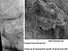
Nili Patera is a 50 km diameter caldera at the center of the Syrtis Major Volcanic Complex.[10] It and Meroe Patera located to the south are the primary named calderas within a nested caldera complex developed by multiple eruption and collapse events.[11] In the Northeast quadrant of Nili Patera is a 630 m tall volcanic cone named Nili Tholus,[10] on and around this cone is a light-tone lava flow of chemically evolved lava[12] with multiple occurrences of relict silica sinter deposits created by a formerly active hot spring system.[13]
Moving sand dunes and ripples

Nili Patera was the subject of a 2010 study into moving sand dunes and wind ripples. The study showed that dunes are active and that sand ripples are actively migrating on the surface of Mars.[14] A following study also showed that the sand dunes move at about the same flux (volume per time) as dunes in Antarctica. This was unexpected because of the thin air and the winds which are weaker than Earth winds. It may be due to "saltation" - ballistic movement of sand grains which travel further in the weaker Mars gravity.
The lee fronts of the dunes in this region move on average 0.5 meters per year (though the selection may be biased here as they only measured dunes with clear lee edges to measure) and the ripples move on average 0.1 meters per year.[15]
Gallery
-
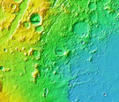
 MOLA map showing boundaries of Syrtis Major Planum and other regions. Colors indicate elevations.
 -
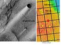 Bright Streaks in Syrtis Major caused by the wind, as seen by THEMIS.


-
 Jezero crater and region
 -
 Water-rich terrain
 -
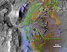
 Possible channel bringing sediment to the crater
 -
 Jezero crater delta - chemical alteration by water (hi-res)
 -
 Detected clay materials suggest an ancient lake


See also
- List of mountains on Mars by height
References
- ^ . E01004.
- ^ a b Staff (4 March 2015). "PIA19303: A Possible Landing Site for the 2020 Mission: Jezero Crater". NASA. Retrieved 7 March 2015.
- ^ a b Wray, James (6 June 2008). "Channel into Jezero Crater Delta". NASA. Retrieved 6 March 2015.
- ^ a b "Mars Odyssey Mission THEMIS web site". 23 October 2006. Retrieved 8 September 2007.
- .
- ^ "Mars Express reveals wind-blown deposits on Mars". European Space Agency. 3 February 2012.
- S2CID 234339942.
- ISBN 978-0-312-24551-1.
- ISBN 0-8165-1641-3. Archived from the originalon 5 July 2004.
- ^ ISSN 2169-9097.
- ISSN 0148-0227.
- S2CID 4401309.
- ISSN 1752-0894.
- .
- S2CID 4415931.[permanent dead link]